Geohazard prediction from seismic applications helps prevent drilling losses
George Schultz, Steve Pickering
WesternGeco
The oil industry spends $20 billion/yr on drilling operations, with about $3 billion attributable to losses. Drill pipe, fluids, rig time, large-scale capital assets, and human life are all at risk in the exploration for oil and gas. One major cause of loss is abnormally high formation pressure, or geopressure.
Quality seismic data holds the key to accurate pre-drill pressure prediction. The behavior of rock velocities with depth reveals a great deal about the state of shale dewatering and compaction, and consequently, the pore pressure that can be expected at depth.
As oil and gas targets become deeper, it becomes more important for drilling engineers to understand pressure environments to properly place well casing points because even one misplaced casing may result in a failure to reach target depth.
Pre-drill assessment of geohazards has, therefore, become an essential component of well planning. When compared with the costs directly related to drilling operations (approaching $500,000 per day), the cost is minor. No well is drilled without such an assessment.
Any pore volume pressures above the weight of a column of water (hydrostatic pressure) are geopressured. Geopressure is caused primarily by disequilibrium compaction.
Causes of geopressure include:
- Tectonic compression
- Aquathermal expansion
- Smectite dehydration of absorbed and adsorbed water
- Smectite to illite shale diagenesis
- Hydrocarbon formation.
Of these, tectonic compression is thought to be most significant. Smectite to illite digenesis is a complex geochemical process and is not fully understood.
Drilling into unanticipated geopressure in permeable sands or carbonates has caused major blowouts, and in comparatively impermeable shales, routinely raises a range of well-bore stability issues.
Shallow water flows
A shallow water flow (SWF) is a deepwater condition normally occurring in water depths in excess of 1,500 ft and in sediments buried at least 1,200 ft beneath the seabed. Submarine fans and turbidite flows can deposit large amounts of sediment in a short time. Enclosed sand bodies encased within the finer-grained muds and shales become overpressured, but are unconsolidated. Bit penetration results in rapid movement of a sand slurry up the borehole, causing mounding on the seabed. Drill pipe can become bent, resulting in complete loss of the hole.
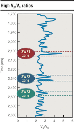
Both velocity in the pressure domain (Vp) and seismic wave velocity (Vs) decrease with increasing fluidity, but Vs decreases much faster, reaching zero in water because water cannot support shear waves. A Vp/Vs ratio can be characteristic of SWF sands because the ratio approaches infinity as the sediments become more fluid. When a high Vp/Vs ratio is located in proximity to an appropriate stratigraphic sequence, the likelihood of a drilling hazard is raised.
WesternGeco uses a five-step process to identify potential shallow-water flow sands:
- Assessment of the data processing flow because a true-amplitude, high frequency broadband signal is needed
- Stratigraphic interpretation to identify depositional facies and environments
- AVO analysis for compressional wave intercept and gradient volumes to yield a pseudo S-wave volume
- Proprietary full waveform prestack inversion to forward-model an observed seismic angle gather. This inverts one-dimensional pseudowell logs of Vp, Vs, density, and Poisson's ratio
- A hybrid inversion of Vp and Vs volumes (combination of the prestack inversion with a poststack inversion), which are then divided to yield a Vp/Vs volume.
Deep pore pressure hazards
At current drilling depths, geopressure can reach levels up to two times hydrostatic pressure. WesternGeco uses a proprietary rock model that accounts for disequilibrium compaction and shale diagenesis.
Velocity information is extracted from seismic data, and through a series of inversion steps, porosity and density information are obtained. From density, an overburden gradient is computed. Then a fracture gradient, normal compaction trend, normal effective stress, and effective stress (pressure between grain-to-grain contacts) curves are obtained. Finally, pore pressure is computed using Terazaghi's principle, which states that overburden is equal to pore pressure plus effective stress.
This process creates a pressure profile that can be accurate to within 0.5 lb/gal of mud weight. This accuracy can be achieved with high-quality seismic data, even in the absence of offset well calibration information.
Summary
Pore pressure service provides a subsurface pore pressure image and identifies unstable formations (SWFs), to aid in exploration risk assessment, well planning, and drilling risk management, based on seismic and rock physics integration.
Large offset P-wave data can identify SWF sands and other hazards. After seismic reprocessing at 2-ms resolution for mapping hazards, prestack full waveform inversion can quantify SWF sands with Vp/Vs ratio.
Seismic can yield pore pressure images to within 0.5 ppg at 10,000 ft, provided that the data has a large offset, is properly migrated and de-multipled, and that the velocities are conditioned and interpreted to extract "rock velocities." Poisson's ratios are extracted from prestack, full waveform inversion.


