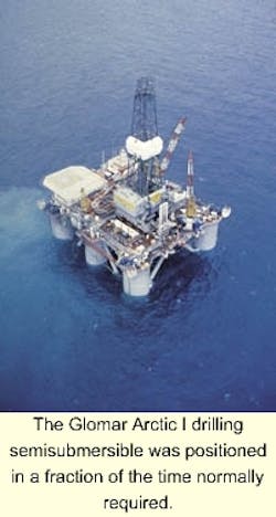
Detailed planning is critical to trouble-free mooring of a rig, especially in greater water depths. When EEX wanted assistance in planning the mobilization of the Glomar Artic I to the Mackerel Prospect in Mississippi Canyon 620, it employed an array of navigation tools, including a Dronetrademark unit, from John E. Chance & Associates.
The Drone (dynamic remotely operated navigation equipment) unit provides navigation guidance to remote vessels by allowing personnel on each vessel of a project to see, in real time, the same data. This fourth generation navigational tool enhances the movement of a rig or barge on location. In addition, it increases safety by allowing operators to view the project dynamics. The Drone unit is being used to position vessels, rigs, pipelay vessels, marine construction, and tension leg platforms.
On the EEX project, the actual mooring time was 55 hours, setting an EEX record for insert wire cut-in on an all-chain rig. EEX's Mackerel Project Manager, Terry Prater, said the process would normally have taken over five days.
Conventional positioning
Prior to development of the unit, remote vessels had only textual information or a simple graphic showing location relative to the target. There was no knowledge of where any other vessels were, and much communication was necessary to keep everyone informed. Now, all vessels involved see an identical map (centered on their vessel, if desired), which shows the location, orientation, task, and other information of every vessel in the network.
When a particular vessel is assigned an anchor, every Drone unit automatically indicates that vessel as associated with the anchor, and shows its target location as well as its range and azimuth to that location. Using the Drone allows deployment of Starfix.navRegistered, a graphical survey and navigation system that incorporates GIS real-time positioning in a comprehensive survey, monitoring, and calculation package. It allows for simultaneous tracking of an unlimited number of vessels while integrating information from Chance's Gulf of Mexico data base, which incorporates 40 years of data on OCS leasing, shipwrecks, block boundary polygons, pipelines, and shipping fairways. Thus, a visual representation of the physical vessel in the work site is available for viewing on the screen.
This Drone screen is replicated on all the vessels participating in a positioning project, allowing better direction and management of operations.
The Starfix.nav program is set up on the main vessel, with a portable Drone unit on each of the remote vessels on the project. The portable Drone unit has two hardware components: the peripheral box and the computer. The peripheral box houses an internal GPS receiver, a radio receiver, and RS-232 serial communications ports. Although the typical configuration of a unit consists of a GPS antenna, a gyro, and a radio antenna, the system is not limited to these devices.
GPS and gyro data for the remote vessel is collected locally and transmitted to the master system via high-speed telemetry link. Likewise, the master system transmits network data to the individual units, including differential corrections and data of other vessels, along with Starfix.nav configuration updates. Thus, the vessels are synchronized by Drone and Starfix.nav.
The system contains a touch screen monitor and the Microsoft Windows NT operating system. It was designed without a keyboard or mouse for inexperienced users. The user can perform simple operations on Drone, such as zooming in and out, but cannot alter data being transmitted over the network. The user has only a handful of choices on a touch screen, including a "restore defaults" option that functions as a fail-safe to return to original settings.
Field control
To direct a vessel to a particular location, the surveyor assigns the vessel a "target" location. Every Drone receives the information and displays the target location, along with a line from the vessel to its target. The display shows the operator which way to navigate to remain on the target line. The textual helmsman display indicates the distance from every vessel to their targets.
At the completion of a job, the Drone unit may stay onboard a vessel. So-equipped vessels can move from one job to another, without having a surveyor visit the vessel. Upon reaching the next job, the map and other data can be shipped to it over the radio and it's ready to start working.
