Large magnitudes of "subsidence" of rumoured Upper Jurassic shallow water sediments to much deeper marine settings in the US (and presumably Campeche Gulf of Mexico deepwater slope margins) may have been caused by latest Jurassic or earliest Cretaceous halokinetic mass slumping of the Louann and Campeche salt wedges flanking the deep zone of oceanic crust as it formed in the central Gulf.
How "deep" was the Gulf of Mexico in Late Jurassic times? Some papers presented during the 21st Bob Perkins GCSSEPM Research Conference hinted at shallow-water depositional environments, even in the deep central Gulf. These may have included reefs, subaerial islands (Buried Hills Trend), and fluvial systems. Others assumed the traditional view of deeper settings. At least one paper suggested a largely non-marine setting in the southeastern Gulf well into Late Jurassic time.
The question is important because the region's best source rocks were probably deposited during the Upper Jurassic. It would be advantageous to understand how these relate to the regional evolutionary picture, both in terms of depositional setting and regional distribution relative to basement types. In addition, shallow-water environments may tend to favour development of certain types of reservoir systems, which have yet to be exploited in the deepwater.
Shallow water hypothesis
Part of the Jurassic shallow-water argument in the deep Gulf is apparently that neritic (shallow water) fauna are being found in Late Jurassic sediments in some of the deep wells on the slope. Also, basal stratal reflectors flanking the deep eastern Gulf abyssal plain have been tied by some to represent similar shallow water environments.
Some workers appear to be pondering the idea of subaerial islands in the deep Gulf right up to MCU time (mid-Cretaceous). These ideas are being bandied around despite the fact that no one seems to have yet identified any large offset, basement-involved faults that cut the Jurassic-earliest Cretaceous section. These ideas are also being put forth despite the fact that most of the Gulf is rimmed by thick reefal escarpments of Lower Cretaceous age. The escarpments attest to the fact that they faced a much deeper, open-water setting in the Central Gulf.
Basin subsidence
From the perspective of basin dynamics and subsidence mechanisms of the lithosphere, such scenarios stretch the bounds of reason. Consider the three types of primary basement subsidence:
- Tectonic subsidence (crustal thinning)
- Load-induced subsidence
- Thermal subsidence.
No one has yet pointed to any basement faults that could have allowed such magnitudes of tectonic subsidence after Late Jurassic time. Until such unlikely faults are found (which would need to circumscribe the entire Gulf), this possibility can be confidently written off.
Load-induced subsidence is certainly not the cause; given that there is no load that could have affected the Gulf other than the thin veneer of Late Jurassic-Early Cretaceous sediments in the Gulf.
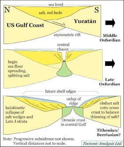
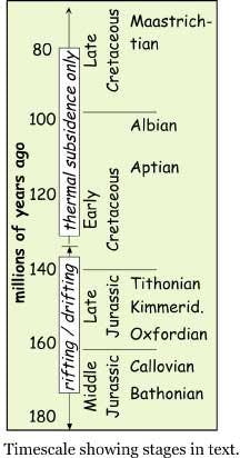
Stages of Gulf of Mexico opening: Late Triassic-Middle Jurassic asymmetric rifting with thick salt deposition, followed by seafloor spreading (drifting) until the Early Cretaceous. Seafloor spreading produced salt walls with overlying shallow water environments. These collapsed toward the central oceanic trough, allowing rapid "halokinetic subsidence" of the Late Jurassic section (from Pindell et al.,2000; Tectonic Analysis Ltd.,2001).
As for thermal subsidence, this only occurs at an exponentially decreasing rate (square root of age/3, ignoring the possible minor role of lateral heat flow into margins). Even with "brand new" oceanic crust, only one kilometer of thermal subsidence can be achieved in 9 million years.
Modelling the Gulf, starting with oceanic crust near sea level (with shallow water environments) at 140 Ma (Late Jurassic), would certainly not recreate the Gulf as we know it. Specifically, it would take 64 Ma (nearing the Maastichtian) to create water depths of only 2.6 km in the eastern Gulf (disregarding sediment fill), which was clearly not the case. Starting with thinned continental crust at sea level at 140 Ma would leave the Gulf even shallower through time.
In either case, the central Gulf would not have reached abyssal depths, nor would the circum-Gulf carbonate escarpments have formed as they did by 115 Ma (Aptian-Albian). Geodynamic modelling accords best with the Gulf if oceanic crust is assumed to have formed normally in Late Jurassic time at depths of 2 to 3 km below long-term sea level.
Central deposition
So, how to justify these claims of Late Jurassic shallow-water deposition so far down the US Gulf slope? One possibility is that shallow water faunal material was transported into a deeper-water setting toward the central Gulf. Another possibility is that the early Gulf was a deep, largely subaerial hole, well below global mean sea level and isolated from the world's ocean. This is plausible, but unlikely during the time of salt deposition (episodic flooding and evaporation cycles). But this is certainly not the answer for the rest of the Jurassic, because the Smackover and Zuloaga formations tell us that open marine conditions had been established well up on the shelf platform by Upper Oxfordian time.
A much more likely answer to the problem stems from events that must have occurred at the onset of seafloor spreading in the Central Gulf, which was probably nearly coeval with the onset of open marine conditions in the Gulf.
Gulf formation
The Gulf formed over two stages, a Late Triassic-Middle Jurassic asymmetric "rift" stage of intra-continental extension and thick (2-3 km?) salt deposition, followed by a "drift" stage of seafloor spreading in the Central Gulf until the earliest Cretaceous when Yucat
Basement beneath the future Gulf slope margins was already 2 or 3 km deep at the onset of seafloor spreading, which separated the Louann and Campeche salt provinces in the Oxfordian. Otherwise, there would have been no accommodation space for the salt. Evaporation drew seawater continuously into the Gulf as basement subsided. The basement/red bed surface probably began to pass through sea level in the Bathonian or Callovian, and salt deposition probably kept the depositional surface near sea level into the Oxfordian. Evaporated water was continuously replaced by a steady influx from a restricted connection(s) to the world's oceans, maintaining hypersaline conditions across the early Gulf over significant periods of time.
The Gulf of Mexico opened during the Middle Jurassic followed by subsidence throughout the Cretaceous.
Sea floor spreading would have effectively begun when igneous dike injection into the rifted margins accommodated most of the continuing plate divergence. In the Gulf, it is probably not significant that the orientation of extension during sea floor spreading was different from extension during continental rifting.
As sea floor spreading became organized between the opposing rifted continental margins, oceanic crust would have been accreted to the rifted margins at roughly the same depths that basement had already achieved. This was 2-3 km below sea level given that the rifted continental margins already had been loaded by thick salt. In places, oceanic crust may have been emplaced slightly shallower (2.6 km below sea level is "normal") than the rifted continental crust, causing an upward step from the base of salt on the rifted margins to the oceanic surface.
If open marine conditions began in the Gulf at about the same time, salt deposition would have ceased, and the two salt provinces we know today (Louann and Campeche) would have been split by the onset of seafloor spreading. Also, onset of open marine conditions would have initiated shallow, but essentially normal, marine deposition on top of the salt, which at this time was still situated near sea level. This tectonic setting can be referred to as a restricted supra-salt platform, and it appears this may have been the depositional setting for regional source rock accumulation. Late Jurassic water depths would have been dependent on the interplay of subsidence versus sediment accumulation rates, but may have deepened somewhat with time.
Salt wall collapse
As seafloor spreading and separation of the two salt wedges ensued in the central Gulf after open marine conditions had been established, an unavoidable co-effect would have been the creation of steep "salt walls" flanking a 2-3 km-deep marine chasm above young, developing oceanic crust. In this chasm, deposition would have comprised pelagic material plus anything that spilled over the flanks of the supra-salt platforms, and may have been quite starved. A clastic source may have entered the Gulf from the southeast, where tectonic interactions took place between the Yucat
How long would these "salt walls" have survived the unavoidable effects of gravity, i.e., large-scale halokinesis? We certainly can expect that the salt would have collapsed under its own weight into the central trough, especially if the depositional surface of the salt itself were tilted basinward, (e.g. on the south-facing footwall of the sinistrally transtensive Pearl River Fault).
Progressive thermal subsidence of the central oceanic crust would also have enhanced basinward tilting of the salt section, and Late Jurassic sedimentation upon the salt would have helped as well. The shallow water marine source rock section above the salt, initiated in the Late Oxfordian, would have collapsed along with the salt. In this manner, Late Jurassic shallow marine environments may have "collapsed" to depths of 2 or 3 km by or within earliest Cretaceous time. By this mechanism, given "normal" oceanic initial basement depths, the apparent large and rapid subsidence of the Upper Jurassic section need not have required basement faults or impossibly fast thermal subsidence.
This mechanism for explaining the rumoured shallow marine Late Jurassic facies associated with salt in the deep Gulf would apply to the section originally deposited above salt only. It would not apply to the section deposited on the early, central oceanic trough, which has not yet been drilled. The seismic interpretation of giant Jurassic reefs situated on this oceanic crust is a highly unlikely interpretation. Other possibilities, such as hydrothermal fluid pathways, should be considered.
Buried Hills in the deep eastern Gulf, considered by some as subaerial early on, may in all likelihood eventually be shown to be leaky transform faults roughly defining small circles around the Gulf of Mexico's Stage 2 Yucat
Halokinesis timing
What about timing of the halokinesis? If a regional detachment for early halokinesis surfaced right around the basement deflection that ultimately defined the position of the Cretaceous reef trend, one might expect to see some flexurally controlled responses to salt movement on the US Gulf Coast Shelf.
It might be worth entertaining the idea that the marine regressions above the Smackover (Upper Oxfordian), Haynesville (Kimmeridgian), and/or Cotton Valley (Tithonian) units may record times when downslope salt movement unloaded the shelf, producing isostatic rebound and uplift. If so, one or more of these unconformities would have little to do with eustasy. In fact, such a mechanism may drive short-term (third order) relative sea level changes at margins around the world.
Conclusion
A clastic rather than carbonate signature for Jurassic-derived oils in the southeastern Gulf should be fully expected. The subaerial surface of the Yucat
References
Pindell, J. L., Kennan, L., and Stephen Barrett, 2000, The Gulf opened like thisellipse.., AAPG Explorer, Geophysical Corner, October, 2000.
Tectonic Analysis, Ltd., 2001 (Pindell, J. L., and Kennan, L.), Exploration Framework Atlas Series, Volume 4, Gulf of Mexico and Mexico, 2nd edition, unpublished non-exclusive commercial exploration atlas, paper and CD-ROM. ([email protected])


