Even with the best quality 3D seismic data, an interpreter can have a troublesome task in defining the salt/sediment boundary at the flanks of a salt dome, salt sheet, or other complex structure. Gravity has commonly been used to address this problem. The major differences in how it was done then and how it is now done are twofold:
- Improved acquisition technology and processed data
- Integrated workstation software tools.
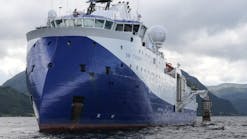
A dip line, shown in red, was selected for the integrated seismic and potential fields earth model. The line is from Fugro Geoteam's Sao Paulo Plateau survey (SPP99) and is orientated from southeast to northwest.
By incorporating a co-recorded data set, with each data set independently measuring a related property of the subsurface, the interpreter can place a much higher degree of confidence in the final geologic interpretation. To quantify this observation, case studies show that incorporating 3D seismic with high resolution gravity and magnetics can alter the base of salt interpretation by several thousand feet from the 3D seismic interpretation alone.
In some cases, results from gravity modeling have provided valuable insights into the geology below a salt body, enabling the seismic processors to refine their migration velocity model, and as a result refine the seismic image through re-migration of the data using the new velocity model.
Resolution advances
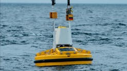
When asked the question: "why do we re-acquire gravity?" our answer must be: "For the same reasons we re-acquire seismic data." Although the gravity fields mapped in prior years have not changed, our ability to accurately measure and process gravity on a ship has improved dramatically, just as we have improved our ability to shoot, record, and process seismic data. Recent advances in gravity measurement at sea include:
- Upgrading from analog to digital control and acquisition systems
- Higher data sampling and recording rates (200 Hz sampling, 1 Hz recording)
- Precise DGPS positioning for removal of ship accelerations
- More accurate measurements of water depth
- New data processing developments (signal to noise enhancement, micro-leveling, etc.)
With these advances, industry has seen major improvements over data recorded as recently as 10 years ago. In many cases, there is an increase of up to 10 times the data per unit area in new surveys over older data, with a correspondingly higher level of confidence in interpreted geological results. Many operators are routinely incorporating new high-resolution gravity into their interpretation projects.
With the trend towards highly focused exploration teams, the smooth interaction and coupling of multiple geophysical disciplines is essential. Explorationists are expected to employ and be familiar with more disciplines on a continuing basis. The development of workstation applications, which enable the interpreter to simultaneously refine the subsurface model using seismic, gravity, and magnetic data, has been a significant step forward in the integration of geophysical techniques.
Brazil example
The process used generated a velocity model constrained by the combination of seismic and potential fields data in a single integrated earth model.
For the past several years unprecedented levels of geophysical data has been acquired offshore Brazil. In this new exploration venue, international oil and gas companies are working to understand the relationship of known fields in adjacent basins, the link of well and geophysical data, and the regional geologic framework.
To provide information for these topics, a large mega-regional survey of seismic, gravity, and magnetic data was recently conducted offshore Brazil. The survey is tied to 103 wells, multiple discoveries, and includes deep seismic records of 12 sec. Lines were acquired across entire basins, or across multiple basins.
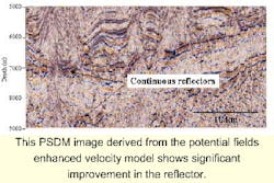
Although the prestack depth migration (PSDM) image is generally easily interpreted, some mid-section and very deep reflectors exhibit significant offsets. From this PSDM image alone it is not possible to unambiguously interpret if these offsets are geologic structures or velocity artifacts.
An enhancement process was used to generate a velocity model constrained by the combination of seismic and potential fields data in a single integrated earth model. The resulting potential-fields-enhanced velocity model was used to generate a PSDM image that shows significant improvement over the PSDM images derived solely from seismic data.
A top-down approach was used to convert the initial velocity model to geologic features located in the upper portion of the earth model. This included bathymetry, the initial salt geometries, and velocity contours. Velocity contours were converted to density contours using Gardner's equation. An empirical velocity-density relationship, rather than Gardner's is recommended, when well data is available.
From the seismic data, the localized high velocity contours below the salt were interpreted to possibly be carbonates, so a density of 2.55 g/cc was assigned to these features. The salt density was 2.15 g/cc.
A bottom-up approach was used to incorporate deep geologic features. This included Moho derived from a modified Airy isostatic formula, and basement derived from conducting a variety of depth estimates techniques on the magnetics data. These deep geologic features are included in the earth model, but are not displayed in the figures.
The earth model was modified using software that enables the simultaneous display of seismic, gravity, and magnetics data. Making reasonable changes to the basement could not minimize the mid-wavelength high amplitude component of the gravity mistie.
Changes to the basement resulted in gravity responses that were of a wavelength far longer than are contained in the difference gravity data. In addition, changes to the basement caused magnetics anomalies that were not contained in the observed data. Simply changing the high-velocity high-density carbonates to high-velocity low-density salt significantly minimized the mid-wavelength, high amplitude, component of the gravity mistie.
After changing the carbonates to salt only small-wavelength, low amplitude (+/- 3 mGal), gravity misties located directly over the shallow salt bodies remained. These misties were minimized to the sub-mGal level by changing the thickness of each salt body. One salt body required only minor changes; two salt bodies were thickened; one salt body was thinned to a weld; and one small salt body was added as a result of the integrated seismic and potential fields modeling.
The comparison of the gravity field computed from the earth model to the observed gravity data was the only factor in determining salt geometries. The inclusion of the additional salt body resulted from inspection of both the gravity and seismic data. A new velocity model was derived by directly converting the integrated earth model from density to velocity for all layers except the deep salt (modified from carbonates). The deep salt was smoothed during the conversion from density to velocity.
Results
The initial integrated earth model and corresponding calculated and observed gravity fields. The 10 mGal mistie between the calculated and observed gravity fields near the middle of the earth model indicates errors in the initial velocity model.
In the PSDM images derived from the potential fields enhanced velocity model, the reflector located below the base of shallow salt moved more than 1 km in depth as a result of the modification of salt geometries in the integrated earth model. As a result, the structural high, or velocity pull up, noted earlier, was resolved. In addition, the deepest reflectors become more continuous over areas of the model where the shallow salt geometries were modified.
The final integrated earth model corrects the misties by adding basement and salt masses to the earth model.
This study was conducted on a single line using a 2D/2.5D modeling algorithm. Owing to the complex nature of most geologic bodies and assumptions inherent to 2D/2.5D modeling, it is best to conduct the process using a 3D earth model when sufficient coverage of potential fields and seismic data are available. Three dimensional seismic data is not required to generate a 3D earth model, however sufficient coverage of 2D lines is required. An iterative approach resulting from multiple loops through the process may be desired in some cases.
All the modifications to the salt in the earth model of this study were based on gravity misties of less than 10 mGal. The majority of the changes to the shallow salt geometry were based on gravity misties of +/- 3 mGal. Although similar modeling results could be obtained by using standard quality land, water-bottom, or marine data it is important to note that the inferior resolution of satellite gravity data make it unsuitable for this type of integrated modeling.
Economic impact
The approach cited here breaks with the traditional approach of gravity and magnetic data used in oil exploration. In years past, the in-house gravity expert or consultant would disappear with all the required data for the modeling process and return to the client with his or her interpretation.
In today's team-oriented exploration environment, the availability and use of real-time interpretation software tools allow for the integration of gravity and magnetic data at the same workstation. This approach is now embraced by a growing number of oil companies for increasing confidence in their geologic interpretations, and decreasing risk.
To be most effective, the integration of gravity and magnetics must take place at the earliest stage of prospect development, and can continue throughout the exploration and prospect maturation process.
Technical and commercial considerations now indicate that all the available geophysical data be incorporated into the depth migration process in order to minimize both time and risk. The application of gravity to seismic velocity and seismic imaging ambiguities has now become a proven technique, in use by a growing number of exploration companies.
Acknowledgement
The authors acknowledge Fugro-Geoteam AS for use of the seismic data, Paradigm Geophysical for PSDM images, Fugro-LCT for permission to use the gravity and magnetics data, Galileo Geophysical for use of the Moho structure from its Atlas (Regional Gravity Fields; South Atlantic-Brazil to West Africa), Dr. Qingbo Liao and Denes Vigh of Paradigm Geophysical and Bob Peebles of Fugro-Geoteam AS for their insight and work. The authors can be reached at [email protected].


