Tied datasets critical to understanding
Neville Exon, Chris Pigrim
Australian Geological Service Organization
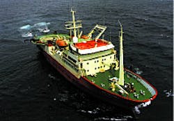
Rig Seismic recording seismic data.
- Vibro-coring aboard Rig Seismic off Sydney as part of a study of the effects of ocean outfalls. [38,009 bytes]
- Box coring aboard Rig Seismic. [33,647 bytes]
- Vibro-coring aboard Rig Seismic off Sydney as part of a study of the effects of sewerage ocean outfalls. [41,748 bytes]
- Locations of seismic lines acquired by Rig Seismic in the Australian region. [35,194 bytes]
- The seabed sample locations from the most recent major Rig Seismic sampling cruise, off Tasmania in 1995. The results from this and previous cruises in the region are summarized in a special issue of the Australian Journal of Earth Sciences, volume 44, number 5. [12,097 bytes]
The multipurpose research vessel Rig Seismic was deployed by the Australian Geological Survey Organization (AGSO) on a series of historical surveys to gather information. All necessary seismic data is now in hand. Other work conducted by the Rig Seismic since 1985 was primarily for petroleum exploration industry clients. Other work included surveys carried out for AusAID (Australian Agency for Inter national Development) and for the New Zealand Government.
The study of Rig Seismic's data, in AGSO and outside, has had a great influence on the understanding of Australia's continental margins. In many poorly explored areas, AGSO seismic data is the only modern data available. For example, surveys off northwest Australia constitute the only high-quality tied dataset that link the Carnarvon Basin through the Browse and Bonaparte Basins into the basins of the Arafura Sea. This dataset was recently augmented by five refraction seismic transects. It presents a unique insight into the structure and composition of the continental crust beneath Australia's major petroleum province.
- Large igneous provinces: Similarly, AGSO's data from the Kerguelen Plateau are the most comprehensive from any of the large igneous provinces that are scattered throughout the oceans, and provide a basis for analyzing how and when these major features form and their role in the processes of ocean basin formation. In October 1998, the Ocean Drilling Program's dynamically positioned JOIDES Resolution started two months of drilling in the Southern Ocean waters. Thousands of meters of core are being recovered to test hypotheses about this igneous province. Much of the seismic data used to locate the drilling sites came from Rig Seismic.
- Structural models: One of the major insights into continental margin formation over the last two decades has been the development of believable structural models, to which AGSO contributed ideas and data derived from the Continental Margins Project research. Other areas of fundamental research include the processes of and controls on carbonate sedimentation and cementation. This is a major inhibitor of subsurface seismic mapping.
- Seismic and sampling: The combination of regional seismic and sampling surveys, and targeted surveys to define drill sites, has preceded the continuous coring by the Ocean Drilling Program (ODP) down to 1,500 meters below the seabed. Early drilling programs were on the Exmouth Plateau, the surrounding abyssal plains, and in the Great Barrier Reef.
- Petroleum traps: High-resolution seismic data acquired by Rig Seismic, in conjunction with geochemical analyses of the seabed sediments and water column, have helped to formulate new ideas on the controls of petroleum trap integrity in the Timor Sea. The concepts developed help explain and predict which traps will be breached and which traps are oil prone or gas prone, thus enabling industry to better evaluate exploration risk.
- Basement data: Dredging and coring from Rig Seismic have revealed a great deal about the basement rocks beneath our sedimentary basins, and the sedimentary sequences that form these basins, especially along the outer North West Shelf, in the Great Barrier Reef, and on the southern and southeastern Australian margins. Coring has helped climatic scientists to piece together the history of Australia's margins, especially during the last 100,000 years. It has also led to a better understanding of sedimentation and geochemical processes in areas as widely separated as the Sahul Shoals on the North West Shelf, the South Tasman Rise, the New South Wales continental shelf, the sewer outfalls off Sydney, and the Great Barrier Reef.
Primary goals
The three main elements of offshore studies of geology and resource potential have been:- To provide pre-competitive data to address negative perceptions of Australia's prospectivity, and to encourage investment in petroleum exploration as part of a broad acreage-release strategy. This ensures that Australia maintains an efficient and effective offshore petroleum exploration industry.
- To help formulate Australian government policy on maritime jurisdiction and on the management of non-living resources. In particular, studies were needed to maximize and sustain Australia's legal Continental Shelf claim under the United Nations Convention on the Law of the Sea (UNCLOS).
- To undertake research into the geological processes that formed the continental margins and that are relevant to both resource exploration and environmental change.
Vessel history
Earlier this year, the Rig Seismic sailed into Brisbane - the last time the vessel entered an Australian port under charter to AGSO. Svitzer Australia Pty Ltd bought her from the Norwegian owners, Uksnoy CO AS, along with much of her equipment. Svitzer intends to use the vessel for commercial geoscience surveys in the Australasian region, and has started with a geotechnical survey in New Zealand.The vessel's last cruise for AGSO was a seismic survey in the northern Tasman Sea in collaboration with French researchers. On this cruise, seismic evidence was obtained of gas hydrate deposits beneath the seabed on the eastern flank of the northern Lord Howe Rise.
Coincidentally, the very first research cruise of the vessel, in February 1985, was also on the Lord Howe Rise. In the intervening 13 years, Rig Seismic has helped AGSO, and its predecessor - BMR, meet Australian national petroleum resource assessment needs in an offshore area that is 1.5 times the area of onshore Australia.
Rig Seismic's Australian saga began with the establishment of the Marine Division in the then Bureau of Mineral Resources, Geology and Geophysics (BMR). Realizing the importance of geologically mapping Australia's huge and resource-rich offshore area, the Australian Government endorsed a Continental Margins Program (CMP) for BMR.
The program was designed to help assess petroleum potential in geographical frontier areas in which exploration companies were not active, and to develop new techniques and ideas in areas where they were active. BMR bare-boat chartered the virtually new 72-meter-long research vessel from Uksnoy. This ship would acquire the data for the CMP.
The vessel was managed initially by the Australian Department of Transport and later by its successor, the Australian Maritime Safety Authority (AMSA), which is continuing to manage her for Uksnoy. BMR provided the technical and scientific crew.
This multipurpose vessel fitted out by BMR for underway geophysical and deepwater-sampling activities, started work in early 1985 with what was by modern standards a modest capability. Thereafter, the capability was gradually transformed, to the point that Rig Seismic became one of the premier seismic research vessels.
Service to AGSO
In 13 years of service, Rig Seismic carried out 68 surveys in support of AGSO's marine geoscience program. Whereas nearly all these surveys acquired seismic data in one form or another, some were multipurpose, and others single-purpose (see the table below). In later years, commercial surveys - mostly seismic, but some geochemical - were more common as the surplus capacity of the vessel was utilized. Thirty-two surveys have been collected since 1991.In 1989, a major refurbishment of seismic acquisition and processing facilities aboard the vessel included a 240-channel seismic streamer, and an array of sleeve guns as the seismic source. Thereafter the vessel's capabilities were equivalent to those of industry, with niches in regional deep-penetration seismic surveying with sleeve guns, and high-resolution surveying with GI guns.
Twenty-one cruises acquired geological samples, either dredge samples from sequences identified in seismic data or cores up to 10 meters long which could be used for multiple purposes. One of the most intensive dredging and coring programs in recent years was carried out off Tasmania.
Cores from around the Australian margins have been used for geochemical studies of hydrocarbon generation, pollution, and phosphate concentration. A towed fish gathered information about hydrocarbons and pollution in the water column. The geological equipment sold to Svitzer with the vessel includes deepsea and hydrographic winches, piston, gravity, box corers, and a vibro-corer.
New AGSO era
RV Rig Seismic has served AGSO over the last 13 years. AGSO's marine and petroleum data activities will now take on a new form. AGSO has sought to use other equipment to diversify its offshore activities:- Portable drill rigs
- Aircraft for aeromagnetic mapping and laser-fluorescence surveys (used to detect leaking petroleum)
- Multi-beam sonar systems for seabed mapping.
Copyright 1998 Oil & Gas Journal. All Rights Reserved.


