Offshore staff
ASKER, Norway – Egypt’s Ministry of Petroleum and Mineral Resources is offering 10 exploration blocks in the Red Sea close to established hydrocarbon production. Closing date for submission of bids is Aug. 1.
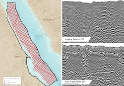
TGS is supporting the licensing round by making available the following data:
- 10,318 km (6,411 mi) of Red Sea ’18 (RS18) 2D long-offset broadband seismic, PSTM/PSDM)
- >16,500 km (10,253 mi) of 2D calibrated vintage seismic
- 3,650 sq km (1,409 sq mi) of reprocessed 3D
- 12 calibrated wells with legacy data (11 with logs)
- Interpretation of vintage data and literature pack
(including gravity, magnetics, seep, geological reports) - Integrated interpretation products of the RS18 seismic, gravity and magnetic data.
According to the company, the Egyptian Red Sea may contain 5 Bbbl of undiscovered but recoverable oil and 112 tcf of natural gas (based on findings from a 2010 report by the US Geological Survey).
Since 1976, more than 27,000 km (16,777 sq mi) of 2D and 4,000 sq km (1,544 sq mi) of 3D seismic have been acquired across the region, while 12 test wells have been drilled on several concessions. These surveys have been either calibrated or reprocessed ahead of the licensing round.
TGS added that activity in the Gulf of Suez has proven the effectiveness of pre- and syn-rift petroleum systems, while offshore Saudi Arabia exploration has confirmed the presence of post-salt plays.
New regional 2D data over the Egyptian Red Sea is said to better illuminate the salt and sub-salt, revealing a link from this frontier basin to the Gulf of Suez and offshore Saudi Arabia. This suggests the African margin may be more prospective than previously thought.
Separately, TGS has issued a report on its latest offshore survey activity.
During 1Q, the company continued its SeaSeep project in the MSGBC basin off northwest Africa. The program will cover an area of around 113,500 sq km (43,822 sq mi) and will incorporate around 230 cores from the seabed, the locations based on multi-beam backscatter anomalies.
Final results will be available this summer.
Acquisition continues of the Jaan 3D survey in the southern portion of the MSGBC basin, designed to provide of 11,135 sq km (4,299 sq mi) of new 3D data plus reprocessing and full pre-stack merging of existing multi-client 3D.
TGS is operating the program in partnership with PGS and GeoPartners. Final data will be available in 2Q 2020.
Activity has re-started for the Brazil Southern Basins SeaSeep project which will eventually cover 200,000 sq km (77,220 sq mi) of the Campos and Santos basins, with final products due to be delivered in 4Q 2019.
Under a joint venture with Spectrum TGS continues to acquire the 15,000-sq km (5,791-sq mi) Santos 3D program over the southern Santos basin, with final data to be issued to clients in 2020.
In March acquisition started of a new 11,200-sq km (4,324-sq mi) multi-client 3D seismic survey over the Campos basin, with fasttrack data available likely to be available this summer ahead of a planned license round.
05/09/2019


