Enhancing 2D seismic using gravity gradiometry as a 3D geologic interpolator in transition zones
Phill Houghton, Steve Carter - ARKeX
Peter Nuttall - IONGEO
Given a choice of seismic acquisition methods, an explorationist prefers good quality 3D seismic data. However, 3D acquisition is not always possible due to costs associated with difficult access issues, size of the area to be covered, permitting, and environmental issues in certain geographies, etc. This is evident in densely populated areas or transition zones.
Lacking 3D data, the next logical choice is 2D seismic acquisition. Often 2D data from legacy acquisition programs are available. However, these data may not have been optimized for the current target depth, with insufficient sampling, offset, and record length. Modern 2D acquisition and the latest processing techniques can solve some of these issues, but the data still is two dimensional. The only choice is to extrapolate and infer the data into 3D space.
Once example of where these issues prevail is the US Gulf Coast. Many of the targeted areas have legacy 2D seismic data not optimized for today’s exploration objectives. Removing uncertainties associated with 2D seismic data still requires 3D information. Airborne gravity gradiometry can solve some of these issues by providing a 3D measurement of the earth’s gravitational field. These data act as an intelligent geologic interpolator among existing 2D seismic data, plus update and validate the velocity field and aid seismic processing.
2D problem
The problems associated with 2D seismic data are well understood. No matter how careful the design and layout of a 2D program there are always limitations and compromises. Any given 2D line may clip or just miss the crest of a structure, which could lead to an incorrect interpretation. This structure is complex. Shallow faulting and salt along and underneath the fault planes makes both imaging in a vertical sense and mapping in a spatial sense difficult. To take these data to depth it is important to understand the complex velocity field. Out of plane issues that could affect a 2D depth migration are difficult to resolve without any independent knowledge of the spatial context of the geology.
Solutions
Modern processing and velocity model building can improve some of the issues associated with 2D acquisition. Application of sophisticated noise and multiple attenuation routines that are able to capture and remove out of plane events are critical. Events appearing where the apex is not at zero offset clearly contaminate the common-depth-point (CDP) gather. Removal of this spurious noise, without impacting the true in-plane data, is critical prior to any pre-stack time and depth imaging. Subsequent high resolution velocity analysis and pre-stack depth migration is important to correctly position the fault walls and subsalt features, but when compared to 3D it is often compromised by lack of statistical stability and spatial context. Calibration with any available well information is valuable, but having an independent measurement of the spatial location and geometry of fault and salt features adds confidence to velocity model building and subsequent depth imaging and regional interpretation.
New workflow
The limitations of 2D seismic are not unlike conventional gravity profiles in that the measurement is two dimensional and its ability to construct a 3D representation of the field will be a function of the line spacing and data sampling interval. A finer grid of 2D lines improves understanding of the measured field and leads to an improved 3D understanding of the earth model.
Full tensor gravity gradiometry measures the rate of change of gravity in three dimensions. The inclusion of offline or sideways looking information is important to reduce the uncertainty in a 2D measurement and can provide an enhanced interpolation solution between sparse acquisition lines.
In addition to the 3D nature of gravity gradiometry, the instrumentation differs from conventional instrumentation and exhibits, higher resolution and increased bandwidth. Typical airborne conventional gravity is limited to a resolution of 1 mgal at a bandwidth of ~17.5 mHz, whereas airborne gravity gradiometry typically obtains <1 Eotvos at 0.2 Hz.
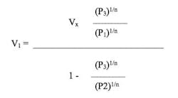
The key factor in using either conventional gravity or gravity gradiometry to aid seismic imaging is in the correct determination of the velocity and density relationship. Due to limited bandwidth and data resolution, a small change in density can give a large uncertainty in velocity. The increased resolution and bandwidth inherent in gravity gradiometry data highlights the advantage in being able to constrain this relationship more accurately. This represents an improvement in the ability to reduce the uncertainty of the velocity field determination and to provide meaningful information at the seismic scale.
The key to unlocking gravity gradiometry data lies in an integrated workflow where the relative merits of each measurement type are exploited. For example, where 2D seismic data provides good coherent reflectors, subsequent seismic interpretation can help calibrate the time to depth function needed to model the gravity gradiometry data. The high confidence in the time seismic data interpretation combined with density information from available wells or suitable analogues determines the velocity to density calibration. This can be calibrated further over several lines until the interpreter has confidence in the functions to be used. Invariably there are areas in the seismic data that lack sufficient energy to yield a coherent reflector, and this is where gravity gradiometry drives the interpretation through a series of modeling iterations using the derived functions.
The interpretation will benefit from the strengths of each data type, and the final interpreted earth model will have converged using independent data in a cooperative workflow.
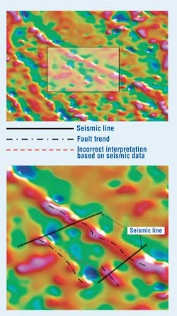
These benefits are not limited to 2D seismic profiles. 3D field gravity gradiometry also can provide spatial information to aid understanding the structural fabric. When faced with two seismic lines several miles apart, it is difficult to appreciate how two independently interpreted faults may or may not be connected. Lacking additional information, the interpreter often simply connects the two fault planes.
This shows an example of how one can incorrectly interpret these data in the absence of 3D spatial information.
A similar problem exists where a seismic line might clip or sit slightly away from a structure (i.e. a salt dome). The additional spatial data provided by gravity gradiometry data can help place the salt body and provide valuable information to the seismic processors.
The final stage of the workflow is to combine all of the information derived from each stage into a 3D inversion. Using the 2D depth converted seismic to constrain the inversion at key horizons, plus any available well logs, the gravity gradiometry data can be used to generate a 3D earth model.
Relationship between velocity and density from conventional gravity measurements. Conventional gravity analysis, left. Gravity gradiometry data analysis,right.
In areas such as the Gulf Coast, acquiring new 3D and 2D seismic is expensive and time consuming. Alternatives need to be considered prior to additional exploration. The transition zone in particular presents challenges, and piecing together the geologic fabric from onshore to offshore has considerable value to exploration companies chasing plays different than those 10 – 20 years ago when the original data acquired.
Modern processing techniques such as those employed by IONGEO can uplift legacy seismic data, and the GulfSPAN provides new insight into the region. However, due to the sparse nature of the 2D data, a true detailed 3D understanding of the geology is lacking.
Gravity gradiometry through its increased bandwidth and resolution can provide valuable information at the seismic scale. This, coupled with the 3D nature of the measurement, means that the data can be integrated with regional 2D seismic data to carry out an improved 3D interpretation.
Authors’ note
Integration of multi-measurements, improved seismic processing algorithms and the development of newly integrated workflows can deliver a combined benefit from these data, with gravity gradiometry as a key dataset to help derive an improved 3D earth model. In conjunction with IONGEO, ARKeX has embarked on a project along the Gulf Coast in Louisiana to demonstrate the advantages of multi-measurement integration in difficult areas.
