Orens Pasqueron de Fommervault, Alseamar
Efraín Rodríguez-Rubio, and Daniel Rincón-Martínez, ICP-Ecopetrol S.A.
Hydrocarbon seeps consist of small amounts of hydrocarbons being expelled from the seabed and reaching the water column. Seeps products, which can be solids, liquids or gases, are direct indicators of the existence of petroleum systems. Although seepage rates are thought to be slow and steady, occasionally and as pressure builds up, large eruptions occur. A number of factors can affect seepage rates, including external elements such as bottom currents, tides, and changes in atmospheric pressure. Nevertheless, those processes are largely unpredictable and still not well understood.
Seep detection methods have evolved to meet the challenges of offshore exploration such as operational risk and cost. The evolution of autonomous platforms and the development of miniaturized low-power consumption hydrocarbon sensors have brought a technological breakthrough that is now available for offshore exploration activities.
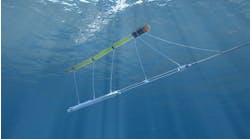
The SeaExplorer glider, developed and commercialized by Alseamar, is an autonomous underwater vehicle that is used for monitoring surveys in both coastal and deep-sea environments. The glider moves passively through the water column, up to 1,000 m (3,280 ft)-depth, by small changes in its buoyancy. In comparison with actively propelled underwater vehicles it has the double advantage to be enduring (several weeks to months) and to not require any support vessel during data acquisition. The platform offers a large maneuverability (vertical profiles, drift, bottom-landing) and can follow a predefined path. Thus, it is especially suited to cover large areas of ocean (thousands of kilometers) and to address processes of broad spatial (meters to kilometers) and temporal (hours to weeks) scales.
Mission in the Colombian Caribbean Sea
Ecopetrol, the national oil company of Colombia, conducted a glider campaign during the second half of 2019 in the Colombian Caribbean Sea. The NOC contracted Alseamar, a glider manufacturer and marine services provider, to acquire in-situ data at sea and to support its offshore exploration activities. The survey involved two SeaExplorer gliders, each of which performed more than three months of continuous monitoring at sea. Both gliders basically embedded a classical conductivity, temperature, and depth (CTD) probe as well as a dissolved oxygen sensor, manufactured by Sea-Bird Scientific. One glider was then equipped with an additional acoustic doppler current profiler (ADCP), while the other one was equipped with an oil and gas-suite configuration.
ADCP measurements have proven to be a powerful tool for metocean monitoring and for the validation of Ecopetrol’s numerical ocean models. They also permitted to monitor water currents in real time, assisting glider operation and supporting data analysis. The following will focus on the oil and gas measurements, which provided the most innovative results. The oil and gas configuration for this specific mission consisted of the following sensors:
• A SeaOWL sensor, manufactured by Sea-Bird Scientific for the measurement of turbidity and fluorescence of chlorophyll-a and oil.
• A MiniFluo-UV oil sensor, manufactured by Alseamar for the measurement of proxy of pyrene and fluorene-like compounds.
• A METS sensor, manufactured by Franatech for the measurement of dissolved methane concentrations.
The survey site was selected by the NOC based on previous ASTER and sentinel satellite observations, which aimed at detecting oil slicks. Results obtained by this method suggested pervasive patches of potential oil slicks in the area, corresponding to variations in the sea surface roughness as well as other physical properties. However, synthetic aperture radar (SAR) images are known to return many “false positives” for oil slicks, caused by natural phenomena which generate patches of similar appearance. Therefore, Ecopetrol required a cost-effective solution to confirm the presence of natural seeps in the water column and accurately locate the hydrocarbon leaking at the seafloor.
Oil and gas detection with glider
The autonomous detection of hydrocarbons in an oceanographic context is challenging. To accurately detect and characterize natural seepages, a faithful data processing and analysis procedure is needed. For the purpose of the mission, data were first converted onto physical units using factory calibration coefficients and adjusted from usual bias (offset, temporal drift, and thermal lag). Resulting data were then converted into anomalies by computation of deviations from a mean state plus a baseline correction. Finally, an automatic procedure had been set up to detect oil and gas seepage using objective thresholds.
Methane is usually used to detect hydrocarbon seeps, being the main constituent of natural gas. In the seven-day methane time-series example, anomalies were very strong. Two significant and persistent methane concentration increases were observed from the seafloor and up to 250 m (820 ft)-depth. Those results provided the evidence of extensive gas seepage during this period. Those events were not isolated and were observed frequently during the three-month survey. To increase the likelihood of detections and to better characterize the nature of the system (maturity, origin), analysis of oil concentrations is also relevant. Most commercially available sensors are based on optical properties. Therefore, they are impacted by natural fluctuations and water mass characteristics, which makes the measurement sensitive. The detection procedure, however, permitted to highlight anomalies relative to the background noise. The anomalies detected with optical sensors were smaller compared to methane-sensor ones, but still statistically significant. Considering that same seven-day time-series example, but for the MiniFluo sensor, one can see oil anomalies that occurred concomitantly with methane increase. For the second event, if detections did not perfectly match in time (one day of difference), they were spatially close.
These data suggest that the site is not only characterized by methane, but also probably by oil seepage. SeaOwl sensor oil data also supported this result (not shown). Although at this stage it is not possible to determine the relationship between near-surface hydrocarbon seepage and subsurface petroleum generation and entrapment, having obtained information on the hydrocarbon charge type (gas versus oil) provides Ecopetrol with relevant information for data-based decision making regarding the acquisition or divestiture of lease blocks in the area.
At a broader scale, the whole glider-dataset collected provides a comprehensive and stationary view of the region. The following charts reveal a spatial coherence between the various parameters and confirms active seepage during the survey period. Highest concentrations were measured in the southwest corner of the area (cluster [1], black triangle). Furthermore, for all oil and gas proxies, a distribution of anomalies is observed along a southwest – northeast axis, parallel to the isobath 400 m (1,132 ft). Latitudinal/longitudinal coordinates were converted into distance (considered positive northward the center of [1]) to evaluate the plume extent. Maximum anomalies (> 500%) were in a radius of around 10 km (6 mi).
Far away, it was observed a background level in the range 0-100%, suggesting the area is characterized by a system of aligned seeps rather than a single seep.
Oil and gas anomalies of smaller magnitude also appeared. Persistent clustering methane detections occurred offshore (cluster [2]). At [2], anomalies were found in intermediate layers (not in the vicinity of the seafloor) and not associated to detectable increase in oil. This suggest only gas was present. A crossed comparison with current measurements would be necessary to determine the source of the gas detected (local seepage or advection from another site).
Conclusion
Glider acquisition provided direct imaging of seepage and confirmed the presence of active petroleum systems in the area. This corroborates results obtained from prior studies based on SAR systems. In addition, glider data permitted to better understand and characterize the area (seepage size, occurrence, etc.). However, bathymetric and seismic re-examination of the area is required to better understand the nature of seepages (i.e. faults, sub-bottom gas flows, diapirs, mud volcanoes, gas hydrates). Having in mind that gliders do not provide hydrocarbon fingerprinting (only presence/absence result), further oil geochemical studies (spectroscopy, isotopy) might also be required.
This survey shows how the SeaExplorer glider is an efficient tool for ground truthing in hydrocarbons detection. The system was able to measure significant methane and oil concentration anomalies. New sensor integration is ongoing to improve the payload capability, obtain more qualitative result, and ultimately get a better understanding of a petroleum system. •
Acknowledgment
The authors would like to thank the crew of the Niña Beatriz (CP-04-1315), who participated to the deployment of the SeaExplorer gliders. They also thank Dirección General Marítima (DIMAR) and Policía Nacional de Colombia personnel for their accompanying offshore and onshore during the mission.


![Deep anomalies plotted against the distance to site [1]. The black curve represents the main envelope of points. Deep anomalies plotted against the distance to site [1]. The black curve represents the main envelope of points.](https://img.offshore-mag.com/files/base/ebm/os/image/2020/03/2003OFFauv_z03.5e7aa0d2f094f.png?auto=format,compress&fit=max&q=45&w=250&width=250)


