Acoustical remote sensing adapting
Seismic technology is being extended into more areas of the drilling and production business, and proving the adaptability of acoustical remote sensing. Recent advances in many geophysical tools now allow more hydrophones in the towed sensing array, geophones with hydrophones at the seabed, and arrays of acoustical sensors within the wellbore.
This means that seismic is not just for gross regional investigations any longer (and has not been for some time). Geoscience professionals can choose the density of seismic control needed for projects throughout the life-cycle of the oil play in a region and for producing oil and gas fields within the trend.
By increasing the density of acoustical sensing over the life of a project, both the reservoir and its fluid contents will reveal their secrets. This means better well placement, better reservoir modeling, and full development of isolated, formerly by-passed reserves.
The seismic business had a rough year in 1999. In 2000, more of these new uses for the evolving seismic method will be tested, applied, and proven. While the tools and principles of the method are well known, our creative application of it to new problems is a wide-open opportunity. The recent revamping of the seismic fleet (see seismic vessel survey in this issue) has brought new vessels into existence and retired others. The technology frontier now moves to towed arrays, processing systems, and new processing algorithms.
With apologies to Wallace Pratt, oil is found and extracted by the mind. No amount of technology will ever find and extract hydrocarbons without creative people.
Riding the e-wave
Creativity is revamping the oil and gas business. Speakers at a Cambridge Energy Research Associates (CERA) conference in Houston said that the primary advantage of the e-business trend is to reduce cycle time on procurement and increase the flow of information to facilitate decisions. However, the potential it offers for additional change and productivity gain is just being explored.
Archie Dunham, CEO and President of Conoco, characterized the changing enviroment as a "woven world" which enhances globalization, privatization, and makes the balancing of risk and reward more critical than ever. Competition is increasing so that clear vision and quick action by companies is critical.
Dunham acknowledged that employees are the creators of value and that knowledge workers are one of the keys for a company's future success. Knowledge is power and today's geo-professionals must take advantage of their specialized know ledge and creative edge to ride the E-wave.
EXPLORATION
Mauritania project
Veritas DGC is processing 3,600 sq km of 3D seismic from offshore Mauritania. The work is being done for Woodside Energy Ltd of Australia. It will be processed in the Singapore facility and supervised from the West Perth facility. About 250 million traces will be processed using full Kirchhoff pre-stack depth migration.
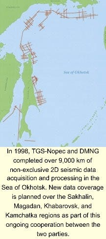
In 1998, TGS-Nopec and DMNG completed over 9,000 km of non-exclusive 2D seismic data acquisition and processing in the Sea of Okhotsk. New data coverage is planned over the Sakhalin, Magadan, Khabarovsk, and Kamchatka regions as part of this ongoing cooperation between the two parties.
New beacons
Leica Geosystems will build a supply of DGPS beacon stations for South Africa. The five-station network will be operated by Portnet Lighthouse Services and will provide navigational accuracy of 10 meters. Leica MX9330 beacons will be used at the reference stations on Cape Columbine, Cape Agulhas, Cape Recife and Cape Cooper.
TECHNOLOGY
Better analysis
Jason Geosystems BV announced Version 5.0 of the Jason Geoscience Workbench. The upgrade includes:
- 3D Reservoir Visualizer and Analyser: an expanded version from version 4.4
- Largo: a rock physics module
- Rocktrace: a module for PP and PS elastic impedence inversion and simultaneous multi-stack inversion for Vp, Vs, and density.
More logs
Geographix announced the addition of raster log capability to its Discoverytrademark suite. The raster logs allow petroleum geologists to incorporate paper-based logs into their integrated interpretation and mapping workflows. Geoscientists may now scan their in-house paper log libraries with any available scanner to create a completely integrated geological, geophysical, and petrophysical interpretation of the subsurface.
Faster processing
CGG's Data Processing and Reservoir Services Division announced the release of Geovecteur® Plus 7.1. The upgrade has improvements in user interfaces, enhanced speed, and new geophysical algorithms. Optimization of pre-stack depth migration has reduced processing time by 40%.
Deeper vision
Veritas DGC is expanding visualization services with the addition of three new centers during the first half of 2000. The company opened its London facility in February, will open a Calgary, Canada facility in March, and is on-track to open a Perth, Australia location in April. A similar system is in Houston.


