Sacrificing pipelines to ice keels
The Terra Nova development offshore Newfoundland is one of the most challenging offshore hydrocarbon projects ever undertaken. The remote location and harsh environmental conditions give rise to unique engineering challenges requiring innovative solutions.Terra Nova is situated in an active iceberg zone. As such, subsea facilities must be protected against icebergs that have the potential to scour along the seabed. Wellhead facilities are therefore being placed beneath the seafloor in large, open excavations called "glory holes." Subsea flowlines are to be trenched and backfilled to provide thermal insulation and on-bottom stability.
This will be the first trenching operation to be performed on the Grand Bank. A proven trenching system is to be used for the work - however, the remoteness of the site, and the local soil conditions present significant challenges.
Overview
The Terra Nova oilfield lies within the Jeanne d'Arc Basin on the North Eastern Grand Bank, approximately 340 km south-east of St John's and 40 km south-east of the Hibernia platform. Water depth in the area is approximately 95 meters, with a tidal range of around 0.9 m. Terra Nova's estimated recoverable reserves of up to 650 million bbl are contained within three distinct fault blocks - Graben, East Flank and Far East.The Terra Nova region seabed region consists of a complex series of bed-forms varying between sand ridges, sand ribbons, sand waves, and mega ripples. These features have been extensively mapped over an extended period of time.
Sea level fluctuations in the region are known to have occurred in the late Pleistocene, around 15,000 years ago. The most recent low sea level was evidently between the existing 80 meters and 110 meters water depth contours across the North Eastern Grand Bank. Shallow sediments in the region have been characterized by these sea level fluctuations and by the effects of glacial ice.
Sediment transport processes are known to occur throughout the Jeanne d'Arc basin, and in water depths of up to 120 meters on the Grand Bank (according to recent findings). This is supported by the observation of mega-ripples in the nearby Hibernia region (in up to 70 meters water depth). It is believed that the vast majority of sediment transport is storm driven. Similar processes are common in the relatively deep waters of the UK Central North Sea.
It should also be noted that seabed geology can be affected locally by iceberg scour. Existing scours have been observed in water depths of up to 200 meters and across the Terra Nova site. Frequencies of ice scour features within the Jeanne d'Arc basin are estimated at 0.1-1.0 scours/100 sq km/year.
Development background
In December 1996, the Grand Banks Alliance (GBA) was selected as the preferred contractor for the field development. The GBA contractor group, with Petro-Canada as project operator, is known as the Terra Nova Alliance (TNA).The development base case of an FPSO vessel linked by flexible flowlines and risers to wellhead templates, protected from scouring icebergs within four excavated glory holes, was established by GBA during the tender and FEED stages of the project in 1996.
The glory holes are to be 11.5-meters deep below the seafloor, with a base width of 22 meters. The base length of the glory holes varies from 22-62 meters, depending on the number of subsea templates to be protected. Side slopes are to be 1:3. Total cost of the Terra Nova development is estimated at C$3.7 billion at 1997 prices. First oil is scheduled for end-2000.
Site investigations
A number of geotechnical and geophysical surveys have been performed in the Terra Nova region over the past 15 years. The three primary sources of data are the geotechnical site investigations performed in 1984, 1988, and 1997. The first two were conducted from vessels of opportunity on which a mobile drilling unit had been placed. These boreholes were typically sampled using percussive techniques.The 1997 site investigation was performed on behalf of Petro-Canada from the drillship MV Norskald. Boreholes were taken at the proposed glory hole locations, across flowline routes and at anchor pile locations. Fifty-seven boreholes were performed to depths of 2.3 - 45 meters below mudline.
In all boreholes, continuous sampling and/or piezocone cone penetration tests were deployed. Push samples were taken using 76 mm OD seamless Shelby tubes. Percussive sampling was adopted in cohesion-less strata where sample recovery was particularly poor using push techniques. These samples were taken using 50 mm OD split spoon and 76 mm OD thick wall Shelby tubes. In addition, grab samples were taken at each of the four glory hole sites for chemical analysis, in support of the necessary spoil dump permits.
At each glory hole site, one deep boring was completed to approximately 42 meters below the mudline. At the East Flank North, Graben North and Graben South sites, a second shallow boring was performed to around 13 meters below mudline. Close inspection of these boreholes reveals that the profile within glory hole depth can be subdivided into three areas:
- Stratum 1: Generally described as loose to medium dense fine sand with occasional gravel and frequent shell fragments. These deposits are discontinuous across the Terra Nova region, being evident in only eight of the borehole locations investigated to depths of 1-2 m below the seabed
- Stratum 2: dense to very dense sand and fine to coarse silty sand with frequent shell fragments. The sand appears to be the dominant deposit within the upper glacial deposits and is 0-9 meters thick, however, it is most commonly encountered 3-7 meters below the seafloor. In two of the flowline route boreholes, a partially cemented material was encountered 0.8 - 1.3 meters below the seafloor, described as weakly to moderately cemented, fine to medium silty sand with frequent shell fragments. However, this hardpan material was found only intermittently, mainly to the north and east of the investigated area, and posed no problems to the geotechnical drilling operation
- Stratum 3: this material consists of a glacial deposit composed of randomly interbedded layers of cohesive and granular soils. The former is the more dominant material and tends to be stiff to very stiff clay of intermediate to very high plasticity, while the granular materials consist of a dense to very dense clayey to silty sand. This deposit is commonly found beneath Stratum 2, generally 3-7 meters below the seabed.
Glory hole construction
Construction of Terra Nova's glory holes represents one of the most challenging subsea construction projects yet undertaken. Approximately 160,000 cu meters of material has to be excavated (assuming side slopes of 1:3) to exacting tolerances in water depths of nearly 100 meters.Following the 1996 FEED study, open glory holes - as opposed to cased glory holes or silos - were identified as the optimum solution for protecting wellhead facilities from scouring icebergs. Independent studies by research organizations in Newfoundland determined the minimum glory hole depth to be 11.5 meters below the original seafloor level. This depth allows for the presence of the wellhead templates, which stand approximately 7.5 meters above the base of the proposed holes.
Key elements influencing construction were identified as environmental conditions, excavation tools and the site's remote location. A detailed invitation to tender for the glory holes excavation contract was issued to the major international dredging contractors and companies with experience in similar offshore operations. Three distinct methods of constructing the holes were identified: clamshell grab, large diameter drill with airlift, and trailer hopper suction dredging.
Exhaustive technical evaluation was then initiated to identify the potential strengths and weaknesses of each method, which included:
- Sensitivity to changes in environmental conditions (including soil conditions)
- Operating efficiency
- Robustness (resistance to break-down and abrasion)
- Track record
- Impact on the environment (disturbance, or pollution of water column).
Laboratory testing revealed the underlying cohesive formation to be a relatively plastic clay. This raised a number of other concerns for excavation tools including "balling-up" of drill bits and effective dumping of excavated soil from a clamshell grab or hopper. The very hard, partially cemented material found in the upper strata at numerous locations could present problems relating to penetration of clamshell grab and/or draghead tips into the stratum.
Following the issue of the ITT documents, the alliance decided to move the location of the proposed wells - and therefore the glory hole and flowline routes - to maximize oil recovery and minimize drilling capex. Relocation of the glory holes approximately 1,400 meters west of the original sites was accepted by a number of the contractors, without introducing qualifications or increasing their original prices.
Trenching
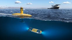
Terra Nova's flexible flowlines, supplied by Coflexip Stena Offshore (CSO), vary from 8-14-in. in diameter. Analyses have shown that the flowlines must be trenched and backfilled for thermal insulation and protection against upheaval buckling (additional download). FEED studies determined that the flowlines should be sacrificial in the event that a scouring iceberg passed through the area, based on the perceived technical difficulties of trenching lines to a depth of up to 3 meters below the seafloor.CSO's Flexjet I system was the base case tool for performing the trenching works. This is a modular, free swimming post-lay trenching system that employs jetting techniques to lower the pipeline below the seafloor. It is based around a Triton T-18 ROV which has been modified to include a caterpillar-tracked propulsion system and a jetting system.
Flexjet I weighs around 12 tons in air and 0-1.5 tons when submerged using a variable buoyancy system. Trenching is achieved using two retractable jetting arms through which high pressure seawater is pumped at 75-125 HP, resulting in a water flow of 11 cu meters/minute at 2.5-10 bar, respectively. Operations apply to waters up to 500 meters deep. Flexjet I was originally designed to trench flexible flowlines and bundles up to 400 mm OD, up to 2 meters below the seafloor.
Jetting techniques are best suited to cohesion-less soils and clays with shear strengths of 5-25 kN/sq m. The flowline passes through the Flexjet I and is lowered into the trench of fluidized soil immediately behind the jetting arms. Trenching rates of 200-600 meters/hour are typical.
Complete burial of the flowlines along their entire length is not required. Pipeline analyses have determined the proportion of the lines that must be buried, and to what depth burial is necessary, to ensure the flowlines' long-term stability. CSO's flowline designers and trenching engineers are investigating whether the required thermal insulation and download can be achieved.
Special challenges of the Terra Nova site trenching include the higher than usual abrasion expected on the jetting arms due to the high concentration of gravel and hard material within the proposed trench depth. Relocation of the flowlines from the routes surveyed in 1997 clearly increases the risk to the trenching operation. Assessments have been performed to quantify this risk and to insure the required performance is met.
New benchmarks will be set by the Terra Nova subsea construction work. A database of knowledge now exists that can benefit future projects in this new frontier region.
Reference
Subsea Geotechnics, organized by IBC UK Conferences in Aberdeen, November 1998.Copyright 1999 Oil & Gas Journal. All Rights Reserved.
