iXblue has broadened its capabilities in subsea navigation, positioning, and imaging with a view to improving its operational efficiency. Over the past 15 months the company has introduced various new products designed to help its clients reduce the costs and times of their offshore campaigns.
One of these developments is Canopus, a 4,000-m (13,123-ft) water depth-rated subsea transponder that can be deployed either in sparse array mode, with the company’s latest generation Ramses ASBL (Acoustic Synthetic BaseLine) transceiver and inertial navigation systems (INS), or in full Long Base Line (LBL) mode.
Canopus provides hundreds of acoustic codes for interrogation and reply. Its environmental temperature, pressure, and inclinometer sensors can be enhanced with Digiquartz depth and sound velocity and can also interface with other external sensors. Other features are internal data logging, a high-speed modem and an accuracy range claimed to be better than 1 cm. The system’s standard battery pack allows for up to 1 million pings, or more than two years’ battery life in listening mode, enhancing the autonomy of operations.
Another development is Canopus’ software, designed to provide a single user interface for controlling and monitoring multiple subsea positioning systems from one location. The software is used initially for planning of an operation, allowing the user to analyze the expected sound velocity profile and digital terrain model in order to assess the likely propagation characteristics, and thereby determine the acoustic range. The user can then develop a beacon array layout, with coverage displayed interactively allowing for easier manipulation, iXblue claims.
The software can also be used to automatically detect and integrate the various devices of the survey/positioning system on the network. Beacons can be programmed over WiFi, and following deployment on the seafloor, can be calibrated using a combination of traditional Box-in, SLAM, or Mutual Array techniques. The software controls all aspects of the array, ensuring that only the correct beacons for the operating area are interrogated, also monitoring positioning performance. Finally, iXblue’s Delph INS (Inertial Navigation System) can perform post-processing of the data. One of this system’s newest features is water density management, providing hydrographic-grade bathymetry with full swell reduction.iXblue’s latest version of its Ramses ASBL transceiver is based on the same electronics platform as Canopus, but with new features to ensure a WiFi user interface. This is an acoustic range meter designed to stop the drift inherent in an INS, with high-accuracy positioning, according to the company. Swedish underwater survey contractor MMT recently used a Ramses in more than 2,000 m (6,562 ft) water depth to steer an ROV to decimetric precision, with only one beacon on the seafloor per 1.8 km (1.12 mi) of the survey route.
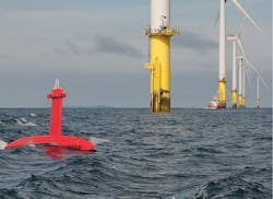
Another new product is DriX, an autonomous underwater survey vessel (AUSV) that can accommodate a hydrographic and geophysical survey payload, and which can be used to assist positioning of underwater vehicles and associated data capture. Bibby HydroMap conducted trials last summer with the vehicle over a five-day period around the 576-MW Gwynt Y Môr wind farm in complex tidal waters off the North Wales coast. Initially, the joint Bibby/iXblue team identified specific locations in order to provide a direct comparison with conventional survey techniques. Then DriX, equipped with a Teledyne RESON SeaBat IDH T50 multi-beam echo-sounder, acquired clean bathymetry at speeds above 8 knots, while remaining on the intended survey line in cross-tides of more than 1.5 knots.
According to iXblue’s VP Energy Market, Olivier Cervantes, DriX was able to sail close to the wind farm piles, with the authorization of the contractor, maintaining a good line and speed at all times. “A comparison with a classical small survey launch showed that DriX achieved a faster survey speed by sailing at 8-10 kn, without line re-run and with efficient line keeping in a high sea state. At the same time the vessel delivered better data quality due to the fact that its sensors were in the Gondola position, 2 m [6.6 ft] below the sea surface. Subsequently Bibby conducted a demonstration on the south coast of England that was witnessed by most of the main players in the renewable energy sector. Now it is proposing DriX in its bids for various other wind farm survey jobs.”
iXblue’s strategy, Cervantes said, is to develop a combination of complementary technologies with open architecture that facilitate interfaces with the client’s preferred equipment. DriX, for example, can be adapted to accommodate multi-beam echo-sounders from alternative suppliers such as Kongsberg Maritime.
Other offshore programs involving the Canopus, Ramses, and DriX systems over the past year have included a box in calibration for proposed development drilling in the Azeri sector of the Caspian Sea. Another new project is a three-year hydrographic survey to provide seabed mapping offshore Tonga, again using a DriX. “It’s a very interesting scenario,” Cervantes said, “with a requirement to operate the vehicle in up to Sea State 5 at a speed of up to 10 kn, which would be four times more efficient than a conventional survey spread for this type of application.” •


