Thunderer Line updates the UKCS petroleum coordinate system
An important step forward was recently taken to ensure the spatial integrity of the UK's offshore geotechnical data. On December 21, 1999, the Oil and Gas Licensing Division of the UK Department of Trade and Industry (DTI) published a notice to clarify the coordinate systems that refer to license boundaries on the UK Continental Shelf (UKCS).
Coordinates describing a position on the earth are only unambiguous if the coordinate system
to which they are referenced is identified. Geographical co-ordinate system components are the geodetic datum and ellipsoid. Projected co-ordinate systems are geographical coordinate systems with a projection transformation applied.
The notice refers to the schedule attached to license agreements of UKCS offshore license boundaries. It acknowledges there may have been some uncertainty in the past and sets out the DTI's interpretation of license boundary coordinates in existing licenses. It also confirms the position, until further notice, as to the geographic coordinate systems that may apply in the case of future license awards.
Petroleum license boundary coordinates have previously been referenced to "European Datum." This term is not a precise one. Several versions of European Datum (ED) exist.
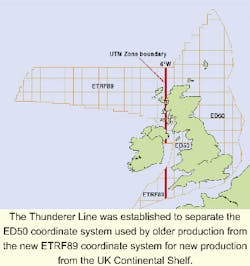
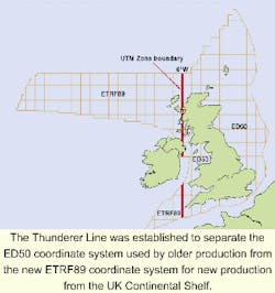
The DTI has chosen to be pragmatic in clarifications. Where the ambiguity in the term European Datum is small, the coordinate system in use by the majority of the industry has been adopted. Where the differences in the interpretation of European Datum are potentially significant, a system has been adopted that can be considered to be coincident with the co-ordinate system used by satellite navigation GPS (global positioning system). A dividing line has been chosen, longitude 6°W in ED50 terms, which is coincident with a UTM zone boundary. This dividing line has been dubbed "the Thunderer Line."
East of the line
The majority of the more mature UKCS exploration and production activity lies east of this line. At the level of positional uncertainty here, there is no business justification for disrupting current practices for the majority of the industry.
To the east of this line, the meaning of "European datum" is clarified as ED50. For UKCS petroleum purposes, ED50 is defined relative to ETRF89 (European Terrestrial Frame 1989) and GPS's WGS 84 (World Geodetic System 1984) using accepted industry transformation methods and transformation parameter values, consistency being preferred to absolute accuracy.
West of the line
West of the Thunderer Line, there is little data existing and, as yet, no oil and gas production. Hence, adoption of a technically preferred system is acceptable and encouraged. Here "European Datum" is clarified as ETRF89.
The safety risk is reduced through adoption of a system which, for all practical purposes, is that used by GPS. The geodetic datum adopted is also consistent with the UK international boundary definitions to the west of Britain.
The Thunderer Line was chosen to be coincident with a UTM zone boundary, where there is normally a discontinuity of projected coordinates. Therefore, there is no change in the number of projected co-ordinate systems in use on the UKCS.
Preferred transforms
Besides declaring the geographic coordinate systems to use, the notice also declares the transformations applicable for petroleum purposes between ED50, ETRF89, OSGB36 and the GPS satellite navigation system's coordinate frame WGS 84. This is a significant step forward in ensuring consistency of use across industry over the whole UKCS. Petroleum industry users can now unambiguously merge positional data throughout the UK and its continental shelf.;
Editor's Note: The author can be reached at [email protected] for further information.

