Wellsite chemostratigraphy
Chemostratigraphy is a powerful but relatively new technique that combines the disciplines of geochemistry and stratigraphy. Developed over the last decade, it uses variations in the whole-rock elemental composition of sediments and sedimentary rocks to identify, subdivide, and correlate stratigraphic sequences. The technique establishes geochemical "fingerprints" for formations of any age and from almost any depositional environment, and has been effective in correlating sequences which contain few or no fossils due to high sedimentation rates.
Sperry-Sun Drilling Services and Westport Technology Center International (both Halliburton Energy Services), in alliance with Chemostrat Ltd., are offering a new wellsite chemostratigraphy service called LaserStrattrademark. A cooperative two-year development program by these companies resulted in a compact, portable, laser-induced breakdown spectroscopy (LIBS) instrument that is capable of analyzing cuttings samples at the wellsite. The service provides chemostratigraphic correlations for better drilling decisions and is useful for picking casing points, coring points, and total depth. It can be used to recognize expanded sedimentary sections, unconformities, and faults (Additional information from Kevin McMillin at Email: [email protected]).
New sources
The Idaho National Engineering and Environmental Laboratory (US Dept. of Energy) and the University of Arkansas have developed two new seismic sources for downhole and marine use: regenerative combustion source and capacitive discharge source. The lab is trying to use conventional source principles and deliver energy close to the bit.
The regenerative combustion source creates acoustic waves by sparking hydrogen gas with an electric fuse. This is suitable for downhole seismic applications and would likely be placed above the bit. The capacitive discharge source uses an electric spark to create an arc in water. The resulting steam bubble creates the acoustic wave similar to current airgun technology. This source has potential for both downhole and marine seismic applications (more information from Tim Green at Email: [email protected]).
Comparing surveys
Keeping up with records in the oil and gas industry is a daily challenge. As soon as one is established, it is quickly superceded. This is especially true with seismic programs.
For the present, the largest 2D survey is being gathered off Brazil. TGS and its partner WesternGeco (formerly Schlumberger Geco Prakla) have recorded over 185,000 km of contiguous 2D seismic without interruption since March 1999. The survey continues and will break at the 200,000 km point later this summer.
EXPLORATION
New Zealand surveys
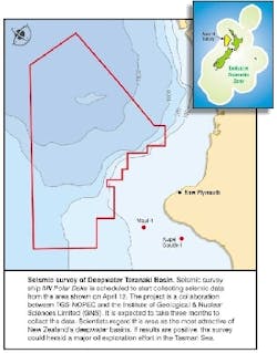
Grant Geophysical is recording a transition zone 3D seismic survey offshore and onshore along the north Taranaki coast of New Zealand for Fletcher Challenge Energy (now part of Shell-Apache). The survey extends up to three km offshore and is a continuation of the recently completed survey shot by the Geco Resolution. It will enable FCE to map the entire Pohokura structure near Motonui. Deepwater seismic acquisition continues as well. TGS-Nopec is gathering a non-exclusive 2D survey covering the deepwater sector of the Taranaki Basin. The 6,800 km survey will provide a regional grid of data and will tie five wells. The project is being shot in collaboration with the New Zealand Institute of Geological and Nuclear Sciences, which will provide data interpretation.
Madagascar 2D survey
Vanco Energy Company began a 1,900-km 2D seismic program over the Majunga Offshore Profond Block in the deepwater Majunga Basin offshore Madagascar. The block covers 14,865 sq km (3.67 million acres) in 1,000-3,000 meter water depths.
Norwegian 3D
TGS-Nopec and WesternGeco are acquiring a non-exclusive 3D survey in Norwegian Sea based on TGS-Nopec's 1997 2D survey acquired in the same area. The survey will cover 2,000 sq km over open acreage. Water depths are in the range of 1,000-1,300 meters. The survey will be jointly financed and owned by TGS-NOPEC and WesternGeco. Final data will be available in time for the 17th licensing round on the Norwegian continental shelf.
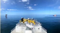
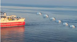
A 3D transition zone survey is being gathered by Grant Geophysical off the northern New Zealand coast for Fletcher Challenge Energy using seven, rigid-hull, inflatable boats and three modified fishing boats.
TECHNOLOGY
Linux/Kirchoff
CGG announced a five-fold increase in its worldwide seismic data processing capacity. The company is investing in 2,000 CPUs of Linux Intel Server Clusters to offer full 3D Kirchhoff pre-stack time migration. The company will run its proprietary TIKIM (Time Kirchhoff Migration) Technology on the new platform. The new clusters will be installed in CGG's Houston, London, and Massy processing hubs.
Interactive data viewing
IndigoPool.com (Schlumberger) announced the addition of seismic and log data visualization technology to its Internet tools. The company is teaming with Interactive Network Technologies (INT) to build additional functionality and flexibility into Log Viewertrademark and Seismic Viewertrademark from INT. This new offering will allow registered site users to find and dynamically view data (not static images) improving online properties evaluations.
VSP recording
Avalon Sciences Ltd. tested its new Geochaintrademark 32-satellite VSP digital seismic recording system earlier this year. The successful trials were conducted in a 2,300 meter open-hole well. The system incorporates geophones, GSP recorder and VSProwess software, allowing up to 32 geophone satellites spaced 1-75 meters apart. The array is capable of operating indefinitely in high temperature (180


