Y. Lafet
B. Roure
P.M. Doyen
H. Buran
R. Taylor
CGGVeritas
Global 4D Inversion is one of a new breed of true 4D algorithms to help squeeze the most out of 4D seismic investments to improve recovery and to get the most out of producing reservoirs.
Together, the combination of 4D Global Inversion and 4D Bayesian fluid classification reduces the uncertainty in 4D seismic interpretation and provides quantitative results in an intuitive framework. As well as maximizing the value of the 4D data, it allows a fuller understanding of the production effects seismic can reliably resolve in a particular reservoir. This allows geophysicists, interpreters, and reservoir engineers to make better informed decisions and fully appreciate what can be achieved with 4D seismic.
4D seismic plays an increasingly important role in managing mature fields. The industry regards 4D seismic as a proven technology with an attractive return on investment. In some mature basins such as the North Sea it can be considered almost mandatory. In fact, it is in the North Sea that the next step in 4D seismic monitoring is being taken with the deployment of permanent Life-of-Field Seismic (LoFS) systems. These permanent ocean-bottom installations allow repeat 4D surveys on demand needing only a source vessel.
With the proliferation of 4D seismic and the prospect of even more to come with LoFS projects, now is a good time to ask, “Are we getting the most out of 4D?” The answer is although we do derive a good deal of value from it, we can do better.
CGGVeritas is a pioneer of time-lapse seismic technology. As part of a new generation of 4D algorithms designed to maximize the value of the technique, the company developed a 4D Global Simultaneous Inversion and Bayesian fluid classification scheme. Together they address the fundamental issues and provide quantitative estimates of fluid distribution for easy, intuitive interpretation.
Quantifying the difference
Typically, 4D seismic is used for qualitative interpretation such as identifying unswept zones in the reservoir. This information is valuable, to identify in-fill drilling targets. However, more accuracy of 4D results and delivery of quantitative estimates of reservoir property variation in a useful format can give a more detailed understanding of the reservoir.
The inversion of seismic data to estimate elastic properties such as Vp, Vs, and density is the first step. 4D analysis is specifically interested in the variation of these properties and trying to interpret them in the context of production effects such as changes in water saturation or pressure.
If these changes (e.g. water saturation has increased to 50% in this reservoir model cell) are quantified, the application of 4D seismic could be used with production data for history matching to update the reservoir model and to make better informed reservoir management decisions.
A new approach for 4D seismic inversion
The challenge is to make 4D inversion more accurate and more exact, and to get the maximum value from investments made in multiple seismic vintages.
Historically, industry compares one vintage with the next and interprets the difference for this single time-step, despite the fact that there may be three, four, or even seven time-lapse datasets. The problem with this approach is that the 4D difference can be subjective. Factors such as differences in acquisition parameters and noise vary from vintage to vintage which means matching will be optimized for just one pair of datasets, not all of them.
With three vintages (A, B, and C), despite our best efforts (A-B) + (B-C) will not equal (A-C). This leaves the question as to which set of results to use. In addition, the inversion of band-limited seismic data is not an exact science. In fact, it is inherently non-unique. This means there always is uncertainty attached to the estimates of reservoir properties for a single dataset. This compounds when you analyze the difference between two datasets.
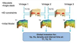
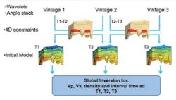
The idea behind a 4D global inversion is that inverting all the data simultaneously gives a single set of best-fit results for all the vintages that give a self-consistent set of 4D differences. In this case (A-B) + (B-C) can equal (A-C) by design. A single pass with this “true 4D” inversion will give a better constrained result with less uncertainty than those obtained from either separate or sequential inversions using one or two vintages at a time.
Tackling uncertainty with rock physics
As well as finding a global best fit solution for all the data, 4D Global Inversion introduces 4D coupling between the results. Using existing knowledge of the reservoir production regime can impose some common-sense rules to guide the inversion. For example, if a field is undergoing water flood we can expect the oil is displaced by water. This can be hard-wired into the inversion to ensure that the results at each time-step evolve in ways which reflect this production presumption.
The 4D coupling is achieved using 4D rock physics constraints. So, for the example above we can perform fluid substitution analysis to determine the appropriate range of variation in the elastic parameters of the model. In this case we may expect a relatively large P-wave velocity increase and a small S-wave velocity decrease within the reservoir sands.
Experience shows that this 4D coupling of the inversion results is important to reduce uncertainty and to obtain quantitative estimates of reservoir properties.
Seismic inversion results are delivered as elastic parameters: P-wave velocity (Vp), S-wave velocity (Vs), and density. These need further interpretation to reveal useful details about lithology and fluid distribution. 4D inversion is interested specifically in the time evolution of the fluid distribution.
CGGVeritas’ 4D Bayesian fluid classification scheme helps with this interpretation. It delivers fluid probability cubes which show fluid distribution in the reservoir at each time-step and express the uncertainty in the results. Unlike the traditional approach of defining different lithology-fluid combinations as a discrete polygon on an elastic attribute cross-plot, the Bayesian fluid classification understands that these lithology classes can overlap. It highlights where fluid distribution can be defined with absolute certainty and where it is ambiguous.
“Attic oil” in the North Sea: A case study
The new inversion and fluid classification workflow was applied to the Brage field of the Norwegian North Sea. The goal was to help identify undrained hydrocarbon sands and to quantify the volume of remaining “attic oil.” If sufficient bypassed and remaining oil could be located with a high degree of certainty, the life of the field could be extended with the attendant economic benefits.
Ten years of production give rise to a prominent 4D signal due to the large vertical movement of the oil/water contact. At the time of the 4D monitor survey in 2003, oil was produced from six wells and reservoir pressure was maintained by water injection.
Depth imaging made an interesting contribution to the 4D study. Originally processed through pre-stack time migration, data acquired in 1992 and 2003 were re-processed through anisotropic (TTI) pre-stack depth migration. The depth re-processing increased the quality of the reservoir image, provided more accurate positioning of the bounding faults, and resulted in better quality pre-stack gathers.
This is a good example of how expertise in other areas of processing such as multiple attenuation and depth imaging can play a role in improving the quality of 4D seismic. In this case, the pre-stack depth gathers were used for the Global 4D Inversion in preference to the pre-stack time gathers.
A key part of an inversion is the definition of the 4D constraints. A “4D mask” was defined by analyzing the 2003-1992 amplitude differences. All cells in the model outside the mask (i.e., with minimal 4D difference) were assumed to be outside of the producing reservoir interval and were forced to have the same values at base and monitor survey times. Inside the reservoir, fluid substitution analysis defined the appropriate ranges of variation for the elastic properties. This was based on a water injection scenario where pressure effects were expected to be small and lead to the definition of these 4D constraints:
- Increase in Vp and density of up to 5%
- Decrease in Vs of up to 2%
It is interesting to see how rock physics constraints actually affect the final fluid distribution probabilities. Global inversion with the “asymmetrical” fluid substitution constraints defined was compared to Global Inversion using some nominal “symmetrical” constraints (i.e. the elastic properties can increase and decrease).
The distribution of high oil/sand probability is much more “focused” with the more stringent rock physics constraints. It yields an estimate of the 2003 oil distribution which has a higher certainty and is easier to interpret. This demonstrates the non-uniqueness of seismic inversion and the importance of introducing 4D constraints to find physically consistent solutions and to reduce uncertainty.
Quantifying the unswept oil
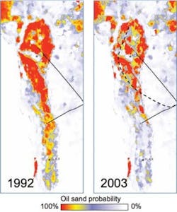
The results of the final 4D Global Inversion and 4D Bayesian fluid classification are shown above. The inversion was performed using asymmetrical rock physics constraints. In addition to the vertical sections, maps of oil/sand probability depict the evolution in fluid distribution during 10 years of production and are consistent with expected effects of the water flooding.
The inversion results are supported by the good overall agreement between the computed 2003 oil/sand probability and the water saturation logged along the path of a horizontal well drilled in 2005.
Editor’s note: The authors thank StatoilHydro for permission to use the case study example.
