Brad Torry
TGS
Although recent advances offshore have brought the comparison much closer, onshore seismic surveys are generally considered to have better statistics for the application of advanced imaging technology and resultant better overall subsurface imaging. Subsequently, one can infer that application of land seismic configurations in the offshore environment would lead to similar enhanced results. With technical, logistical, and operational advances, this opportunity now exists, and data results validate the assumptions. The resultant technology is a game-changer for uncovering and developing new reserves and reducing risk in offshore drilling.
Operational considerations
From a base perspective, considering today’s available technology, onshore surveys represent a static array (grid) of source and receiver points that fundamentally have no size limits, other than cost. Now, highly regularized (azimuths and offsets) data volume can be created that samples each subsurface point multiple times, with the number of times depending on the density of source and receiver points.
In offshore seismic data acquisition, a towed (non-static) array of source and receivers is used. In contrast to onshore acquisition, there is a limitation of what effective amount of equipment (number of streamers and length) is operationally viable, and so it becomes a natural consequence that limitations to the subsurface statistics exist. Increased regularization of the data requires multiple passes of towed arrays in varying directions to provide the approximation of a land survey; although, the number of times each subsurface point is sampled is generally still reduced over a land survey due to the non-static array.
In both scenarios, it remains true that continual advances in technology have led to improved configurations and data capture, which directly correlate to enhanced subsurface statistics and resultant subsurface imaging.
Certain technologies have benefited both onshore and offshore seismic acquisition - quality and sensitivity of sensors and sources, improved positioning technologies, improved equipment deployment and improved electronics and power utilization. This being said, operational limitations offshore still exceed those of an onshore survey.
Emerging technology
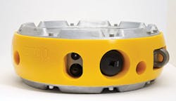
Initially applied in the onshore environment, the development of autonomous nodes represented a game changer for onshore operators. Historically, key limitations were the need to link sensors with cables that transmit data back to the central recording unit, which captures the raw data. Challenges included cumbersome cables; increased time for deployment; limitations in the distance between sensors; and inherent problems, including that a break in the cable or electronic short could functionally shut down the entire system.
The introduction of autonomous nodes moved the industry to a system without cable requirements; no sensor spacing limitations; no requirement for interconnectivity (to capture the raw data); and with advanced battery life technology. Today, operational limitations are minimal.
On the marine side, early 3D offshore recording was represented by narrow azimuth (NAZ) multi-streamer (4-6) single source operations. From here, the industry moved to wide azimuth (WAZ) recordings (6-10 streamer arrays with inline offsets to 8 km or 5 mi) with dual source. With an acceleration of technology advances similar to onshore, today, access exists to wide azimuth long offset (WAZ-LO); multi-wide azimuth (MWAZ); various configurations of full azimuth (FAZ) data sets with offsets to 18 km (11 mi) and beyond; and more regularized statistics (azimuth and offsets).
Today, technology has advanced so that autonomous nodes can be placed on the seafloor in configurations similar to land surveys. Considering the improved operational efficiencies that continue to bring costs in line with FAZ-type offshore surveys, and most importantly, the significant uplift in the statistics and subsurface coverage of offshore data, new standards are attainable with ocean bottom node (OBN) surveys.
GoM data sets
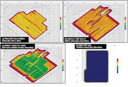
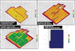
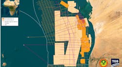
The best representation of this is provided through traditional survey design analysis. TGS recently studied and compared the results of data statistics (not modeled) from deploying multiple acquisition configurations in the Gulf of Mexico.
The resultant folds of these various methods showed a number of telling stories. WAZ data provided good coverage overall with limited holes (some low fold areas) in subsurface coverage. Moving to the next stage of technology application, WAZ-LO showed the increased impact of multi-vessel survey configurations and surface obstructions as significant data coverage holes exist. The size and nature of these data holes is dependent on the exact vessel configurations, weather, currents, and operational regulatory restrictions. By combining multi-directional WAZ data to create MWAZ data alleviated some of the coverage issues and created an improved data volume; however low fold areas remained around obstructions.
The same statistics obtained by acquiring OBN data showed clear results. Given that none of the operational limitations of streamer data applied in a material manner, TGS was able to acquire regularized data without holes and with subsurface coverage that was nominally 10 times that of traditional MWAZ data.
Conclusions from the corresponding “rose diagram” representing the overall subsurface contributions of raw data from the respective offsets and azimuth are also straight forward: The OBN data has significantly higher sampling of each subsurface point, and the distribution of the subsurface data is regularized across all offsets and azimuths. In summary, both the high fold and increased data regularization contribute to increased confidence (de-risking) of subsurface objectives.
Imaging technology
Concurrently with the advancement of field acquisition technology has been the computational and algorithmic advancements in seismic imaging. With the increasing richness in azimuths and offsets, the sheer volume of data has also increased.
Combined with the computational efficiency gains has been the development and adoption of new, advanced imaging algorithms, which take the raw data and covert it to subsurface images. Key benchmark applications have included depth migration (versus time) applications to handle the complex structural and salt tectonics and heterogeneities within the sediments.
As with all technologies that encompass a predictive capacity, the statistics (volume, quality, regularization) of the input data have material implications to the final product. In today’s economic climate, the reliability and risk reduction capacity of the final products become critical. From a simplistic viewpoint, the cost of one GoM outer continental shelf block of high-resolution OBN seismic data equates to less than 2% the cost of a shallow-water well and less than 0.3% of a deepwater well. From this, one can conclude that any material uplift in subsurface imaging from OBN data is worth the effort.
Conclusion
Historically, the industry has been limited by operational or cost limitations. Based on access to new OBN technology, the configurations are limitless and the logistical encumbrances have been significantly reduced.
The evolution of OBN technology enables data-driven acquisition geometries that lead to improved subsurface imaging. Combining this with advanced data analysis of derivative products and calibration to advanced log data should lead companies to higher return on investment; improved risk reduction; and accelerate the pace of unlocking the prize.
