Sercel expands seismic survey planning, OBN product portfolio
Offshore staff
NANTES, France — Sercel has released MetaBlue, a marine seismic survey planning and management tool designed to help E&P companies and marine seismic service providers reduce project times through connecting each phase of a seismic acquisition project.
MetaBlue is said to bring together all the information relating to an offshore seismic survey, allowing all parties to access and exploit the different data from the various survey technologies and equipment used throughout a survey.
That includes Sercel’s navigation and planning software, EMS-based node portfolio, towed-streamer technology, advanced source solutions and survey optimization services.
Through leveraging all the survey data within the MetaBlue ecosystem, users can take decisions at each stage of the survey to support project planning, execution and completion.
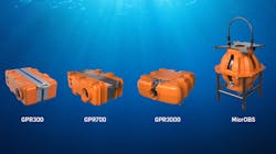
Sercel also now claims to offer a full portfolio of seabed nodal solutions for all water depths down to 6,000 m to meet growing demand for ocean-bottom node (OBN) seismic surveys, based on its low-noise QuietSeis broadband digital sensor technology, including the GPR300, the GPR700, GPR3000 and MicrOBS.
GPR300, launched in 2021, was designed for seismic acquisition in shallow water down to 300 m, and it has since been used to deploy more than 50,000 nodes.
GPR700, announced this week at the IMAGE 2023 convention in Houston, extends OBN survey operations to the limits of the continental shelf at water depths of up to 700 m.
In response to emerging needs for deepwater exploration, Sercel is offering a GPR3000 nodal solution for high-density OBN surveys down to 3,000 m.
Finally, the MicrOBS sparse nodal solution is targeted at sparse deepwater OBN operations down to 6,000 m.
09.01.2023
