Offshore staff
ASKER, Norway – TGS has issued updates on various seismic surveys in its latest results statement.
Offshore Brazil, the Santos multi-client 3D Phase 4 survey is under way over the western portion of the Santos basin: this will be a northwest extension of the existing TGS Santos 3D, covering around 5,000 sq km (1,930 sq mi).
Full-volume fast-track data should be available next March, with final data expected in October 2022.
Acquisition has also started of the Pelotas 2D Phase 3 survey over the Pelotas basin off southern Brazil, an extension of the existing TGS Pelotas 2D data.
In Norway, TGS has released data from the Greater Castberg Topseis seismic survey in the Barents Sea, acquired in partnership with CGG. The high-resolution survey has imaged shallow targets in an area that includes production licenses and open acreage.
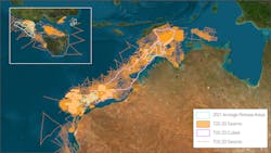
Offshore Australia, TGS completed acquisition of three 3D multi-client seismic surveys from Polarcus covering 12,200 sq km (4,710 sq mi) over prospective offshore basins. And the company is reprocessing Kyranis 3D, a 9,024-sq km (3,484-sq mi) cross-border multi-client seismic survey over exploration blocks offshore Timor-Leste and Australia.
This should provide 3D broadband PSDM imaging for the first time over an area recently re-opened for exploration following ratification of the Maritime Boundary Treaty.
In the Gulf of Mexico, TGS has initiated a new 6,175-sq km (2,384-sq mi) OBC and NAZ imaging program, Sophies Resolve Refocus, representing the next phase of imaging over the mature, hydrocarbon-producing areas of South Timbalier, Grand Isle, and Ewing Bank.
The company is applying its proprietary Dynamic Matching FWI imaging technology to help sharpen definition of notable subsurface structures and provide new insight into the prospectivity of the deeper sub-salt section.
07/22/2021


