Phil Hayes and Roger Taylor, CGG
The Central North Sea (CNS) is a mature basin that has seen many generations of seismic acquisition and imaging over its lifetime. It remains a difficult area for seismic imaging with shallow-water multiples, shallow gas and channel features obscuring the reservoirs in Lower Tertiary submarine fan systems, Cretaceous chalks, and Upper Jurassic sandstone plays.
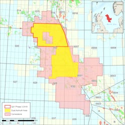
Advances in seismic imaging have led to the view that data should be re-imaged every three to five years, and be “ground-up” reprocessed every five to 10 years to take advantage of the impact of new technologies to re-evaluate the geology. The first figure shows how CNS seismic images have evolved over the last decade.CGG’s multi-client data set in the CNS, known as Cornerstone, includes more than 35,000 sq km (13,514 sq mi) of conventional data along with 14,000 sq km (5,405 sq mi) of multi-sensor and BroadSeis broadband data, which provides dual-azimuth coverage. To quantify the benefits of a full reprocessing of these data sets, two pilot projects were commissioned. A new non-linear “Evolution” workflow was used for both pilot studies, starting from field data.
The Evolution workflow represents a new paradigm and is a way to integrate the latest technologies to ensure the best results. Rather than follow a sequential testing and production workflow with final products only being made available at the end of the project, pre-processing testing was run in parallel with fully-3D imaged interpretation-ready volumes and reservoir attributes being repeatedly produced during the project. These were subjected to detailed, reservoir-focused QC, and allowed feedback from asset team end-users to be incorporated into the workflow. This ensured that the final image volumes met expectations, and pre-stack products suitable for reservoir characterization were also delivered at each evolution. In mature basins, these products are increasingly important to improve understanding of the existing reservoirs and identify new play models.
The goal of the Cornerstone Evolution reprocessing pilots was to address the shortcomings of the previous results caused by the area’s geological challenges and various data vintages spanning two decades of seismic acquisition technology. Specific objectives included:
• Creating a seamless broadband data set
• Improving de-ghosting using 3D techniques to mitigate the tuning effects of thin beds
• Improving multiple attenuation to achieve better amplitude preservation, especially at lower frequencies, for reservoir characterization
• Creating a high-resolution velocity model that more accurately represents the structure
• Introducing attenuation (Q) to overcome imaging issues caused by shallow gas and channel anomalies
• Utilizing high-end imaging algorithms that fully exploit the latest high-resolution Earth models
• Improving imaging of Jurassic targets.
“Ground-up” reprocessing
A key limitation of the legacy towed-streamer seismic data is the narrow bandwidth. Source and receiver ghost energy naturally limits the usable bandwidth, yielding a peak frequency of around 35 Hz. Starting from the original field data, and applying the latest designature and deghosting techniques, broadband wavelets were obtained which were more consistent across the different vintages. For more recently acquired surveys, the near-field hydrophone QC recordings from the source arrays could be used to further improve the bubble attenuation and zero-phasing.
In the CNS area, multiples are rampant and mask the reservoir interval arrivals. Successful attenuation without damaging the underlying primary reflection energy is a significant challenge. A major update involved replacing the previous generation of short-period demultiple technology, based on predictive deconvolution in the Tau-P domain, with a cascaded sequence of newer model-based and data-driven inversion-based techniques such as model-based water-layer demultiple (MWD), followed by 3D surface-related multiple elimination.
A 3D recursive implementation of MWD was used which more accurately models the amplitude, phase, and timing of the water-layer generated multiples. This was so accurate in the low frequencies (below 12 Hz) that it required no adaption to the input, and minimal time and phase adaption in the remaining bandwidth. Another useful new technique is wave-equation deconvolution (Poole, 2018). This uses least-squares inversion to derive an image of features that generate upgoing multiples that can then be used to predict and subtract them from the input data.
Building a better Earth model
A key objective for the Cornerstone reprocessing pilots was to more accurately represent the near surface and associated anomalies. These anomalies could not be successfully resolved by previous interpretation and tomography-driven solutions in this shallow-water setting due to the conventional towed-streamer acquisition geometry, which lacks the far-offset reflectivity to generate a reliable set of residual moveout (RMO) picks for tomography.
A new joint tomography technique was used, with both reflection and refraction picks being used in a joint update of velocity and anisotropy (Allemand et al., 2017). The first break picks provide additional stability and help to produce a model that honors the diving waves while also producing flat gathers.
Refraction-based full-waveform inversion (FWI) has been proven as an invaluable tool for building high-resolution shallow velocity models. Fully data-driven, it does not rely on any assumptions regarding geological structure, or on the availability and quality of RMO picks. FWI proved to be an effective and reliable tool in this shallow-water environment.
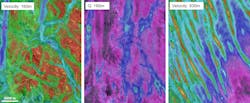
To take the definition of shallow anomalies a step further, attenuation (Q) was incorporated into the velocity model to deal with shallow gas pockets. FWI updating both velocity and Q (Xiao et al., 2018) was used to produce a high-resolution model of the near surface as shown in the following examples. Including Q in the update avoids the risk of cross-talk between velocity and Q in the model building workflow, which would result in erroneous velocities.
Advanced imaging
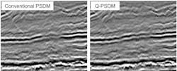
The calculation of a Q model enabled the use of Q-imaging to compensate for phase and amplitude effects caused by attenuation anomalies and resolve the related imaging issues on both large and small scales across the survey. The following figure shows a clear improvement in “push-down” effects observed in the migration that does not use phase Q-compensation.
Reservoir-focused results
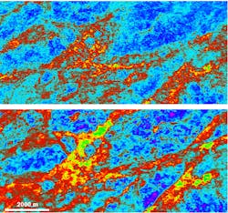
The use of a reservoir-focused processing and imaging flow contributed to a significant uplift in image quality and quantitative interpretation (QI) attributes. The AVO QC attributes were generated after each key processing stage to ensure that the seismic data would be compliant with any requirements for later reservoir characterization work. These attributes could also be used to ensure that AVO features, identified from the legacy data, were continually improved as a result of the reprocessing. The main QC attribute of choice over this region was the Vp/Vs ratio, which has been used as a facies differentiator.
Conclusion
Based on the results from the pilot projects, it was decided that the recent advances in signal processing, demultiple, Earth model building and imaging provided a convincing case to reprocess the 49,000-sq km (18,919-sq mi) Cornerstone data set, comprised of seismic surveys spanning two decades. A new iterative Evolution workflow approach was used to derive the reprocessing sequence with an emphasis on the AVO QC of fully-migrated seismic volumes at each significant stage in the sequence.
The pilot projects overcame the area’s key challenges, including shallow-water multiples, shallow velocity and absorption anomalies. A range of play types and depths were successfully imaged with accurate amplitudes and pre-stack quantitative interpretation attributes for reservoir characterization.
Highlights of the reprocessing sequence included 3D deghosting, model- and inversion-based demultiple, incorporating Q-FWI into the model-building sequence and the use of advanced Q-imaging algorithms including Q-least squares migration. Rigorous AVO QC and calibration through well-ties, throughout the processing sequence, ensured preservation of the amplitude response for reservoir characterization. AVO attribute QC products also delivered early insight into the lithologies and facies of the area.
The current results represent a major step-change in image quality in the CNS and will help to satisfy the needs of the operators to optimize production and look for near-field development opportunities, for at least the next few years, until the continuous march of seismic technology provides the next step-change. •
Acknowledgments
The authors thank CGG Multi-Client & New Ventures for permission to publish this work, as well as the data processing and Research & Development teams who collaborated to deploy the new technologies used in this project.
References
Allemand, T., A. Sedova, A. and Hermant, O. [2017]. Flattening common image gathers after full-waveform inversion: the challenge of anisotropy estimation. 88th Annual International Meeting, SEG, Expanded Abstracts, 1410-1415.
Hayes, P., Townsend M., [2019] Implementing new technology to revitalize Central North Sea seismic via evolutionary processing 81st EAGE Conference and Exhibition, Extended Abstracts.
Hayes, P., Twigger, L., Ubik, K., Latter, T., Purcell, C., Xiao, B. and Ratcliffe, A., [2018] Increasing resolution in the North Sea. First Break, 36, no. 12, 105-111.
Poole, G., [2019] Shallow water surface related multiple attenuation using multi-sailline 3D deconvolution imaging. 81st EAGE Conference and Exhibition, Extended Abstracts.
Xiao, B., A. Ratcliffe, T. Latter, Y. Xie, and M. Wang, [2018]. Inverting near-surface absorption bodies with full-waveform inversion: a case study from the North Viking Graben in the Norwegian North Sea. 80th EAGE Conference and Exhibition, Extended Abstracts.

