Offshore staff
ASKER, Norway – TGS has provided updates on its current offshore geoscience campaigns.
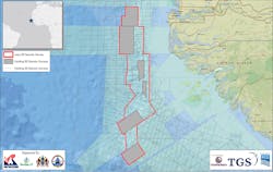
During 2Q, the company continued its SeaSeep project in the MSGBC basin off northwest Africa.
This will cover around 113,500 sq km (43,822 sq mi) and will incorporate around 230 cores from the seabed, located based on multi-beam backscatter anomalies. Final results are due late next year.
Acquisition is progressing of the Jaan 3D survey in the southern portion of the basin, comprising 11,135 sq km (4,299 sq mi) of new data complemented by reprocessing and full pre-stack merging of existing multi-client 3D.
TGS is the operator and majority investor with PGS and GeoPartners. Final data is expected to be delivered next spring.
Another collaboration with WesternGeco concerns reprocessing of 3,600 sq km (1,390 sq mi) of 3D seismic data over the Red Sea.
Much of this will cover open blocks in the 2019 Red Sea License Round. Final data will appear from August onwards, ahead of the closing date for the round on Sept. 15.
TGS has re-started work on the Brazil Southern Basins SeaSeep project, covering more than 210,000 sq km (81,081 sq mi) over the Campos and Santos basins. It expects final product deliverables to be available during the fall.
Over the prospective southern Santos basin, the company and Spectrum have been acquiring the 15,000-sq km (5,791-sq mi) Santos 3D program, with final data set to be issued in 2020.
Fasttrack data from TGS’ multi-client 3D survey over 11,200 sq km (4,324 sq mi) of the Campos basin should be available this summer, ahead of Brazil’s planned license round.The 5,000-sq km (1,930-sq mi) North Tablelands 3D survey offshore eastern Canada, in partnership with PGS, should finish shortly, likewise the partnership’s current 12,500-km (7,767-mi) Southeast Grand Banks 2019 2D survey.
In the US Gulf of Mexico, TGS and WesternGeco are working on the 2,758-sq km (1,065-sq mi) Amendment Phase 1 multi-client ocean-bottom node project over the Mississippi Canyon and Atwater Valley protraction areas.
It is said to be the first large-scale multi-client sparse node program in this area. Acquisition should be completed later this summer with final data available next spring.
Over the Norwegian North Sea, TGS and AGS, re-started acquisition of the Utisra OBN survey. The 2019 portion will be around 800 sq km (309 sq mi), and acquisition will be finish during the fall.
The 7,000-sq km (2,703-sq mi) Atlantic Margin survey should be completed in late 3Q.
Finally, TGS claims to have developed a breakthrough machine-learning algorithm for salt model building, named SaltNet, which it claims can cut significantly the imaging cycle time for complex salt basins.
07/25/2019


