Autonomous vehicle concept demonstrates variety of practical field uses
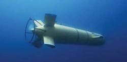
Field use of theAsterX autonomous underwater vehicle (AUV) shows that the AUV concept has practical value.
From February 2004 to January 2007, theAsterX was submerged at sea for more than 1,000 hours. Statistics from these missions are:
- Max depth of 2,500 m (8,202 ft)
- Max distance in one dive of 45 km (28 mi), surfacing once
- Mean operational team of three people
- Mobilization from seven vessels.
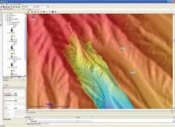
TheAsterX provided data that were used to create a high-resolution underwater map (EM2000). The AUV gathered the data while cruising at 3 knots (3.5 mph) at 60 m (197 ft) off bottom in rough terrain, from 300 to 1,000 m (984-3,281 ft) water depths. The trajectory crossed the lines perpendicularly, climbing with a pitch to keep the vehicle’s axis parallel to the mean slope and descending at a constant altitude.
The cost of mapping was optimized, in terms of time of survey: 18 km (11 mi) in line; 3 sq km (1 sq mi); covered in 3 hours; with the map built on the ship 30 minutes after the end of the dive. This illustrates the data cost optimization achieved by minimizing ship time versus survey time.
More recently, a gas detection payload composed of two fishery echo-sounders (70 kHz and 200 kHz) was installed during the 2006 “Bionil” cruise off the Nil Fan in the Mediterranean on board the R/VMeteor. Fishery echo-sounders can detect gas plumes by giving the intensity of each echo in the water column under its transducer. Gas has good acoustic reflectivity, giving indications of plumes near the seafloor.
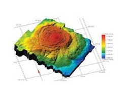
During this cruise, theAsterX demonstrated new capabilities. It traveled for 139 km (86 mi) in 41 hours over six separate dives, mapping several mud volcanoes and small pop marks with the EM2000 multibeam, indicating gas sweep activities. This project was the first for an AUV fitted with a fishery echo-sounder used to detect gas.
A second vehicle was designed and built in 2005-2006. The new vehicle is an optimization of theAsterX with several evolutions to reduce maintenance costs.
Operational AUVs still have a learning curve. Developments are under way to reach higher levels of autonomy and behavioral robustness at sea. For example, new high-level programming mission preparation systems are being designed for mission building and high-level, fault tolerant control. New payload developments also are under way to accommodate instrumental modularity on the system (e.g. a new chirp sediment sounder and an in situ spectrometer).
Scientific requests to use theAsterX AUV are very high (220 days at sea in 2006, for example), and with the experience gained during the last 18 months, a second coastal AUV has been launched with several optimizations based on the validated AsterX concept.
The offshore AUV development effort started with the supervised AUVSirene, designed for accurate launch and deployment of a benthic station. The technology developed in Sirene was applied to the Swimmer research and development project undertaken by Ifremer in collaboration with Cybernetix. This hybrid AUV, based on Sirene, carries a classical ROV and was designed to dock on a pre-installed bottom-station linked by a permanent umbilical to the surface.
The successful development of theSwimmer was followed by a prototype AUV built in collaboration with Cybernetix, Hitec-Horten, and Herriot Watt University.
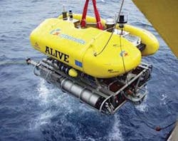
This prototype was known as theAlive intervention AUV. Alive was fitted with manipulators, the first time this was done to an AUV. The vehicle can dock with grabbers on a typical offshore ROV panel in an acoustically supervised mode. This project demonstrated optical and acoustical dynamic positioning and sensor-based docking at sea in real conditions.
Beyond these technological advances, the need for a more classical survey AUV arose in Ifremer’s environmental work in the field of physics, chemical analysis, living resources survey, and risk assessment for geophysics (slope instabilities and seismic surveys). The requirements have led to the launch of an operational program for a fleet of coastal survey AUVs, but with the objective of reducing the cost of operation on a basis of 50 to 100 days per year over 10 years.
The analysis of requirements, collected from several French and European oceanographic institutes, has led to the specification of a 600-800 kg (1,323-1,764 lb), 3,000 m (9,842 ft) depth-rated, modular vehicle with a range of more than 100 km (62 mi), and a 200-kg (441-lb) payload capacity. For coastal applications, this vehicle would be operated by a limited crew from an opportunity vessel less than 30 m (98 ft) long.
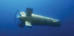
TheAsterX was the first AUV developed to meet these requirements. It is 4.5 m (14.75 ft) long with a diameter of 0.69 m (2.3 ft). Depending on the payload, it weighs between 600 and 800 kg (1,232-1,764 lb) in air, with a diving depth capability of 3,000 m (9,842 ft). The AsterX cruises at 0.5 to 2.5 m/sec (1.5 to 8.2 ft/sec). It can carry various payloads for a spectrum of applications. Typical payloads are designed for:
- Current profiling and physical-chemical parameter measurement
- Sonar imaging for fish-stock evaluation
- Bathymetric sonar, sub-bottom sounder and side-scan seabed investigation.
The use of such an AUV in occupied or high-traffic areas dictates rules for usage following an evaluation of operational risks. This need has led to operation scenarios in which the vehicle surfaces only if an escort vessel can manage the security on the surface. Otherwise, the vehicle cannot surface without acoustic contact with the escort vessel and remains underwater or on the bottom awaiting the command to surface from the escort vessel. For this reason, acoustic communication and relocation functions are included.
