TGS extends floating LiDAR buoy coverage to more East Coast offshore wind areas
Offshore staff
OSLO, Norway — TGS is expanding its multiclient offshore wind and metocean measurement campaign off the US East Coast.
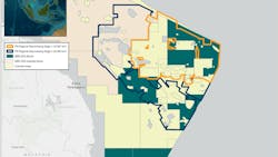
The company has committed to four further deployments of its floating LiDAR buoy, in addition to the one operating in the New York Bight.
These comprise one offshore Massachusetts, two over areas covered by the impending Central Atlantic lease round, and another in the New York Bight area to support data collection and wind modeling of this lease area.
Allowing multiple users access to the same floating LiDAR data offers benefits such as reduced development costs, timelines, and the ability to minimize energy uncertainty, TGS said.
In the Central Atlantic region, the buoys will provide data and insights on a subscription basis to potential wind farm developers, helping them to de-risk prospects in advance of the lease bidding process, due to open in 2024.
The first LIDAR buoy in the New York Bight is delivering high data recovery rates, the company added, and measuring unique aspects of the wind resource not captured by previous modeling studies or measurement campaigns. Adding a second should further reduce wind and ocean modeling uncertainties and cycle times for site assessments, also validating TGS' numerical weather prediction (NWP) model data coverage.
All the floating LiDAR systems have stage 3 validation from EOLOS for their accuracy. Data are acquired continuously and made available to users daily via the Wind AXIOM platform, TGS' site evaluation, and wind data analytics tool.
This is designed to instantly access and process large amounts of site-specific data via the cloud, allowing wind developers to determine factors affecting the viability of their projects and address questions on energy output, annual revenue and supply fluctuations.
03.09.2023
