Ocean forecasting flows into the Gulf
Current technology saves time, money
Jaime Kammerzell
Gulf of Mexico Editor
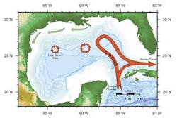
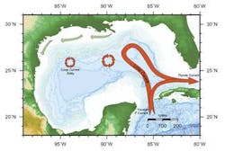
A strong flow of water can wreak havoc on a deepwater Gulf of Mexico oil and gas project. The Loop Current that flows through the GoM brings with it warm water from the Caribbean Sea through the Yucatan Strait. It turns south-east, flows past the southern tip of Florida, and out into the Atlantic, which spawns the Gulf Stream. The Loop Current moves at speeds of 3-4 knots, whereas a normal current flows at rates under a half a knot.
In the GoM, the Loop Current path and intensity varies. Occasionally the Loop pinches off and forms a new anti-cyclonic warm core eddy. Eddies tend to meander west and south across the Gulf for up to three months into drilling lease areas while rotating clockwise. Until recently, the oil and gas industry has used satellites to track and monitor eddies. Accurately predicting ocean currents in the Gulf can save drilling companies millions of dollars in downtime.
Current predictions
Oceanographic services company Horizon Marine Inc. started the Eddy Watch advisory service in the Gulf of Mexico in 1984. The company provides ocean current maps emphasizing the position and strength of the Loop Current and eddies. Horizon uses current meters, drifting buoys, sea surface temperature satellite images, ocean color, altimetry, sea surface measurements, ship-board and aerial surveys, and numerical models.
Two companies, Fugro GEOS and Wilkens Weather Technologies, have launched new forecasting technology to assist the industry.
null
Two is greater than one
Fugro GEOS, in partnership with the Nansen Environmental and Remote Sensing Center and Collecte Localization Satellites, has formed Ocean Numerics Ltd. to provide Ocean FOCUS software technology to the Gulf of Mexico. This technology combines satellite and in-situ ocean observations with numerical modeling to forecast the Loop Current and eddies.
Satellite technology can measure three features of the GoM waters: radiometer measurements of sea surface temperature, altimeter measurements of sea surface height, and spectrometer measurements of ocean color. The sea surface imagery distinguishes between cold and warm water temperatures found in the Loop Current in the winter. However, the temperature differences are not clear in the summer months. Altimetry from four satellites measures the sea surface height. The warmer water in the Loop Current and eddies are at a higher sea surface and at higher current velocities. Ocean color indicates phytoplankton concentrations, which are a good tracer of ocean features. Blue water, indicating reduced primary production in the surface water, is found in the Loop Current and eddies.
Numerical modeling in combination with satellite observations makes for a more effective forecast, Rob Smith, Fugro GEOS sales and marketing manager and oceanographer, said.
The basis of the Ocean FOCUS technology is the Hybrid Coordinate Model (HYCOM) ocean circulation model. The Ocean FOCUS implementation of HYCOM covers the combined Arctic and Atlantic basins with a horizontal grid spacing of between 18 km and 35 km. In the GoM, the configuration provides 5-km resolution to through the water column in 22 vertical layers from the sea surface to the ocean floor.
Advanced data assimilation techniques are used to position features in the model from satellite observation. The model supplies a current velocity profile and layered time series information out to 28 days. Ocean Numerics has used HYCOM for regional ocean modeling joint industry programs for oil and gas majors in West Africa and Europe. Ocean FOCUS has been tested and proved against last year's Eddy Sargassum Loop Current event, Smith said.
"Ocean FOCUS provides detailed ocean information for exploration, drilling, construction, and production activities," Smith said. "The technology helps reduce capital expenditures, operating costs, downtime, and scheduling changes while enhancing operational efficiency, safety, and planning effectiveness."
Ocean FOCUS provides current velocity maps, animations, and recent satellite images at various zoom levels. An interpretative forecast commentary can also be derived from the information by an experienced operational oceanographer. The software also provides forecast site-specific behavior, current time series charts at selectable levels through the water column, and current velocity profiles.
All of the information is available via a secure Web site, email, or fax, with information presented in forms easily interpreted by industry workers on the rigs.
Ocean FOCUS became available in the GoM on a free trial basis in July.
"In the trial period, we will seek user feedback," David Szabo, Ocean Numerics managing director, said.
The service will start commercially in September. Szabo said different packages of information for construction, drilling, pipelaying, etc., will likely be available at that time.
Deep thinking
Using Nowcasting Pro, Wilkens is predicting loop current and eddy paths using high-resolution data. The Nowcasting technology is based out of Ireland and has a relationship with the Danish Hydrological Institute that predicts surface and subsurface currents in the North Sea and now the GoM.
Nowcasting teamed up with Wilkens to break into the GoM market. Wilkens is developing the technology to better serve workers in the GoM.
"We are doubling the resolution from to 1/12th to 1/24th of a degree," Linda Uselman, director business development, said. "Right now the satellite telemetry is from two satellites, and eventually, that will be increased to accommodate three more, for a total of five, which will help the accuracy."
Wilkens will also extend the southern boarder of the Nowcasting Pro model past Trinidad into the southern Caribbean Sea. The further the distance is from starting Point A to area of interest Point B, the better the model is initialized. Wilkens hopes to provide forecasting services to companies working off Trinidad later this summer.
The oil and gas industry has a lot of surface data from satellites, but Nowcasting Pro provides data on currents at depths. The Wilkens model can judge the outer boundary by within 10-15 mi in the Central Gulf. The model also does well forecasting the center of the eddy, and when the resolution doubles, it should catch more of the meanders, Wilkins said.
Wilkens can forecast weather out to seven days in six hour increments for the first 72 hrs. With the Nowcasting Pro high-resolution two-day forecast, Wilkens provides all the weather and current parameters in hourly increments for the first 24 hr, and 3-hr increments the next 24 hr. The forecasting tool works based on detailed weather parameter alerts that the user sets.
Nowcasting can give data based on wind speed and direction at 10 m and 50 m, show significant wave height, swell height, swell period and direction, and sea surface current. The user can also download the data and analyze it offline to save communications costs.
Nowcasting Pro is a short-term forecast, which is software based. The long-term forecast for weather and currents is currently accessed through a password-protected Web site.
null
null
React, plan, capitalize
Nowcasting Pro, users can react to an eddy. Wilkens cited a situation where a rig was headed westward at 4 knots, not realizing it was headed into the core of an eddy with eastward flowing 3-4 knot currents. The rig did not make any progress after one day, so the captain consulted an oceanographer who suggested redirecting the rig 5-10 mi north out of the eddy. The rig proceeded westward with no problems.
The Nowcasting Pro can also assist in planning ahead for an eddy. The captain of Transocean's Discovery Seven Seas knew the Nelson Eddy was approaching. When he saw a change in wave roughness, he put two more generators online in preparation to deal with the eddy. When the front was 10 ft in front of the bow, the captain changed heading from 290° to 320° and needed the extra power from the additional generators to do so.
Users of the model can even capitalize on an eddy. Wilkens mentioned a rig that detoured 50 mi east to follow the Loop Current. The normal rig transit speed was 2.5-3.2 knots. In the Loop Current the rig speed averaged 4.8 knots, which saved 30 hours in travel time.


