Geosciences
Victor Schmidt • Houston
Outsourcing
The strongest trend in evidence at the recent American Association of Petroleum Geologists convention in Dallas, Texas, should be a boon to all service providers. Outsourcing is the wave of the present and will carry the industry well into the future.
In a show announcement, Landmark Graphics (Halliburton) noted its success over the past few years in helping oil companies fill gaps in their workforce and bring lower priority projects to completion. The outsourcing need has grown so large that a separate services and consulting division was needed.
What this means for geoscientists is a strong shift to project-based work outside of the traditional oil company structure. Oil companies will need all levels of outsourced services as they continue to focus their in-house scientific resources on the highest value exploration and development projects.
Structural change in the industry creates a space for service companies to leap ahead of oil companies and provide better-specialized services than can be done within the oil companies themselves. Lower priority areas will still need exploration, investigation, and evaluation. Older fields will need redevelopment and optimization. The work must still be done, but it will be outsourced in individual projects instead of by long-term oil company employees.
GoM DeepShelf maps
TGS-Nopec completed the eastern half of its Gulf of Mexico DeepShelf interpretation project of the entire Louisiana shelf. Subsurface Consultants Inc. completed the project, which features horizons from Lower Pliocene to Oligocene, mapped regionally across Eugene Island through the Grand Isle OCS regions.
The project aids geologic understanding of the deep gas play by creating regional structure maps using long-offset seismic data from TGSN's Phase 50 seismic grid. Hundreds of deep wells and paleo information were incorporated in the study.
The maps are designed for quarterly updates with new well information. The western half of DeepShelf will be completed this month.
Deepwater performance
Knowledge Reservoir launched Reservoir KB, a web-based, deepwater reservoir performance knowledge base for the Gulf of Mexico. The module incorporates information from 54 deepwater fields in production as well as 18 sanctioned fields. It includes detailed reservoir performance data from 81 reservoirs and 264 wells.
TECHNOLOGY
Log format
A2D Technologies has released technical specifications for RasterML, a new calibrated image format. The format uses XML-based technology to describe depth-calibrated well-log images for exchange over networks.
Depth-calibrated smartRASTER well-log images are TIFF files, or well-log scans, that have information about the log type, log-curve scales, measured depth positions, and unique well identifier.
PC Intellex
Energy Graphics has released a PC version of its Intellex Exploration System software for oil and gas exploration data and mapping. The software includes proprietary Gulf of Mexico data and provides functions for data management, mapping, and reporting.
New software capabilities include exporting of shape files and workstation files, and access to the company's well log database. The software includes an updated version of Intellex Report, which features a log database link and 3D Block, which displays all lease block data in 3D.
Bandwidth
Schlumberger Information Solutions (SIS) has begun Bandwidth-on-Demand (BoD), a connectivity service that optimizes network performance and tightens control of network operating costs. This service is unavailable from traditional telecommunication providers for global oil and gas operators.
EXPLORATION
TGS-Nopec surveys
null
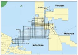
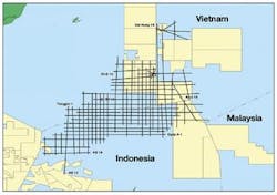
TGS-Nopec is acquiring a 9,300-km non-exclusive 2D seismic survey, called Heimdall, in Indonesian and Vietnamese waters. Data acquisition began March 2004 in the West Natuna, Nam Con Song, and East Natuna basins.
In June 2003, after 25 years of negotiation, Vietnam and Indonesia signed a maritime boundary agreement in the South China Sea preparing this area for exploration. The area will be offered in separate bid rounds during the second half of 2005.
TGS-Nopec also announced a 25,000-km multi-client 2D program in the North Sea. The survey is part of the 100,000-km North Sea Renaissance project and will be acquired by the Polar Princess towing an 8,000-m streamer. Two additional vessels will join the program later and gather data through the end of the third quarter. The survey will available by the end of 2004.
CGG surveys
Agip KCO has awarded Compagnie Générale de Géophysique (CGG) a 700-sq-km 3D seismic survey in the North Caspian Sea over Aktote and Kairan prospects. Agip KCO, as consortium operator, acted on behalf of Eni, Total, ExxonMobil, BG, Shell Kazakhstan BV, ConocoPhillips, and Inpex.
The survey will begin this quarter and will be gathered in 1-3 m water depths. CGG will work with Kazakhstancaspishelf (KCS), a subsidiary of KazMunaiGaz.
Libya's National Oil Co. awarded CGG rights to shoot a 38,000 line-km multi-client 2D seismic program over the entire Libyan offshore. The survey will be gathered in co-operation with North African Geophysical Co. This dataset is the first regional program offshore Libya and the first modern dataset tying the shelf to deepwater basins.
Operations begin this quarter with seismic, gravimetric, and magnetic acquisition over all licensed and open acreage.

