EAGE touches range of technologies
Gene Kliewer, Technology Editor, Subsea & Seismic
The European Association of Geoscientists and Engineers (EAGE) held its annual convention and exhibition recently in Rome andOffshore was there. The following are excerpts from several of the presentations and papers given at the meeting.
Realistic 3D Modeling Based on Advanced Interpretation and Geomodeling Techniques
F. Pivot, A. Price, and J.N. Ferry of Total
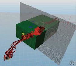
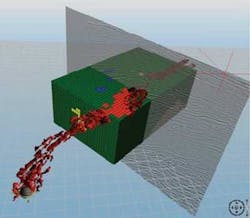
Marine control source electromagnetic (mCSEM) surveys have a level of maturity that requires it to be integrated into the 3D exploration workflow. To build realistic models for feasibility testing, including all the information available from seismic and geological interpretation, methods must be incorporated to map the complexities of the subsurface, and to measure impacts of topology or scale changes. This paper describes such a methodology and its application to a case study in a turbiditic deep offshore environment.
The prospective target has average burial of 900 m (2,953 ft) for a water depth of about 1,100 m (3,609 ft). High quality seismic data are available with multi-angle cubes to allow generation of detailed images of the sandy fairways.
Moreover, AVO analysis increases the probability of mapping particular fluids. However, detailed sedimentological interpretation underlines high risk for the sealing of the trap, as possible leakage points are identified. Additionally, no target is identified by flat-spot or any other direct hydrocarbon indicator.
By combining geomodeling tools, recent advances in seismic interpretation, and 3D mCSEM modeling tools, it is possible to create and fill a very realistic mCSEM “sugar-box” model and to compute CSEM responses of a set of probable scenarios covering uncertainties identified in a prospective area. The procedure is fast and allows rapid development of understanding what additional information can be brought by an mCSEM acquisition. A proposed workflow spelled out in the paper gives a method to integrate mCSEM in the suite of interpretation tools.
Improved Marine 4D Repeatability Using an Automated Vessel, Source and Receiver Positioning System
J.O. Paulsen & G. Brown of WesternGeco
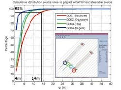
A new automated and integrated, vessel, source, and receiver control system has been developed to improve the accuracy and repeatability of 4D surveys. The new control system replaces operator intervention with automated updates to vessel, source, and streamer steering devices using positioning information from in-sea equipment. This has lead to an increase in the accuracy of source repeatability (2.5-m repeat accuracy for 95% of shotpoints), and also has improved the ability to repeat receiver positions.
The dynamic spread control (DSC) system provides accurate feather match for lines with dynamically changing feather, provided that the current strength is less than the operating capability of the streamer steering devices. The DSC system improves source position accuracy. A major part of this improvement comes from the automation which takes the place of operator intervention.
A new, integrated steering controller, called Q-Pilot automatically steers the vessel, the sources, and the streamers for the best possible 4D position match. In the development of the system, three important features were identified:
- 1. Automation – It is not possible for an operator to accurately predict the behavior of the towed spread and the vessel in a changing current environment.
- 2. Independent source steering – Very tight specifications on source position repeatability are not possible to achieve even with optimal and automated vessel steering. Controlling the source position independently is vital and means the vessel may be steered to position the front end to improve the receiver repeatability.
- 3. Planning and QC – Planning the 4D survey acquisition is more involved and requires more care than for a regular exploration 3D survey. Hence, dedicated software was developed to provide an optimized navigation plan (NavPlan) for each 4D monitor survey.
Co-injection of Seawater and Produced Water to Improve Oil Recovery from Fractured North Sea Chalk Oil Reservoirs
T. Puntervold, S. Strand, & T. Austad of the University of Stavanger
Carbonate oil reservoirs often are fractured with moderate water-wet conditions which prevent spontaneous imbibitions of water into the matrix blocks. Average oil recovery from carbonates is usually less than 30%.
Recent chalk core studies from the North Sea show that seawater is able to change the wettability towards a more water-wet condition at temperatures >100 °C (212° F). Seawater contains favorable concentrations of the potential determining ions Ca2+, Mg2+, and SO42- that are active in the displacement of strongly adsorbed carboxylic material from the chalk surface.
During seawater injection, the initial formation water mixes partly with seawater. The amount and composition of the produced water varies with time. For environmental reasons, produced water should be re-injected together with seawater into the chalk formation.
The question is: Will mixtures of seawater and produced water displace oil in a similarly good manner as pure seawater?
This work showed that at >100° C, the oil recovery using PW:SSW-mixtures was significantly higher than by using pure PW in a spontaneous imbibition process. In a viscous flood, SSW appeared to be more efficient than PW to displace the oil, and high recovery values were reached.
Above approximately 100° C, mixtures of PW and SSW (2:1, 1:1, 1:2 and 1:8) displaced oil from chalk cores of low water-wetness by spontaneous imbibition. No difference in oil recovery was observed for the various PW:SSW-mixtures. Due to wettability alteration, the oil recovery was about twice the recovery obtained by using PW without sulfate present.
SSW also enhanced the oil recovery by viscous displacement due to wettability modification at temperatures above 100 °C. The oil recovery by injecting SSW can be regarded as a tertiary method.
Below 100 °C, the oil was displaced in spontaneous imbibition without a significant wettability modification, i.e. there was no significant difference in oil recovery between PW and mixtures of PW and SSW.
Circular Geometry for Wide-azimuth Towedstreamer Acquisition
N. Moldoveanu of Schlumberger
The potential benefits of full azimuth seismic acquisition by towing streamers in coils rather than straight lines were outlined by Moldoveanu. In his presentation, Moldoveanu said that circular geometry is efficient for towed-streamer wide angle azimuth surveys because only a single streamer vessel with a single source array is needed, and also because acquisition is continuous.
WesternGeco modeled a parallel versus circular survey over one area, and Moldoveanu said the results were positive for the circular method with proper streamer steering, accurate receiver positioning, and advanced noise attenuation.
The simulation was for four parallel passes over 900 sq km (347 sq mi) using one streamer vessel and three source vessels compared to the circular geometry over the same area. The test indicated that the parallel acquisition would require 62 days with 160,000 shots while the concentric run should take 61 days for 321,706 shots. This larger number of shots in the circular run plus the higher fold and wider range of azimuths worked in its favor.
The time is at 100% vessel utilization.
A Gulf of Mexico feasibility test also was run to check the ability to make circular runs. One vessel with one source array and 10 steerable streamers 7,000 m (4.4 mi) long with 120-m separation were used. The test proved it was possible to sail in circles while maintaining constant streamer separation. Data acquired also were processed to confirm that could be completed successfully, too.
Ultra-deep Gas Play Fairway - Gulf of Mexico Shelf, Texas and Louisiana (Best of AAPG)
C.L. Farmer (BP America Inc), D.H. Phillips (BP America Inc), R.H. Benthien (BP America Inc), D.V. Dailey (BP America Inc), B.W. Horn (BP America Inc) & D.G. Derbecker (BP America Inc)
Ultra deep drilling on the Gulf of Mexico shelf targets a new deep gas play fairway below established production. The fairway extends from the Mississippi delta across the Texas shelf in the section below 25,000 ft (7,620 m).
Large, relatively simple anticlines with inverted Paleogene and Cretaceous sediment packages have been identified. These packages have been mapped regionally and locally to identify isopach thicks that should be favorable for accumulation of reservoir sandstone. The main exploration risks for these ultra deep fairways are reservoir presence and quality.
The targeted deep structures contain sediments with internal ponded geometries with thickening axes coincident with present day anticlinal axes. Closure on many of the deep inversion anticlines formed early as a result of initial autochthonous salt withdrawal.
The deep structures are de-coupled from the shallower growth faulted section. Restoration of the structures through geological time indicates a complex interaction between salt thickness, depositional thickening, and structural geometry.
Comparison of structures across the ultra deep trend shows important differences in the depositional and structural evolution of the anticlines. Three-dimensional seismic data is used to interpret some of the differences in depositional and structural history. Internal geometries of sediment packages are identified in their current structural setting as well as in their original depositional setting by flattening on major time horizons. Viewing seismic data in this manner assists in understanding inversion history related to evacuation of the underlying autochthonous salt.
Depth Imaging Beneath a Seismic Obscured Area
O. Knoth, N.D. Whitmore - ConocoPhillips
To image beneath a seismic obscured area (SOA) on the Eldfisk field, ConocoPhillips and partners applied depth imaging using OBC data with converted waves.
The challenge came from overburden effects mostly in the Miocene. Laterally compact, low-velocity streaks combined with compartmentalized and overpressured thick shales to distort the wave travel through it.
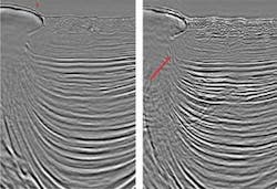
In 2006/2007 ConocoPhillips and its co-ventures reprocessed OBC data from 2001 with improved multiple attenuation, converted wave preprocessing, and depth imaging to uplift the reservoir image within the SOA. This significantly reduced the SOA area (conservative ~30%) for the pressure data and a much improved converted wave image of the reservoir.
The velocity field used in depth imaging was consistent with the expectations of a sharp lateral transition and exhibited both extremely low velocities (1,450 m/s [4,757 ft/s] at 1.8 km [5,905 ft] deep) and lateral transition (up to 30% reduction for 1,000 m [3,281 ft] lateral distance). The workflows and techniques were novel regarding the role detailed interpretation filled in the constraint tomography and how synthetic modeling helped understand the imaging problem.
Reprocessing addressed the following:
- 1. Multiple attenuation improvement
- 2. Velocity model building in an environment of low gradient, vertical gradient, and low reflectivity (Miocene to Oligocene)
- 3. Converted wave pre-processing to examine vector fidelity issues anticipated in the OBC data
- 4. Anisotropy, both for the PZ data and PS data. VTI was assumed but the HTI component for the converted wave was an unknown.
Re-processing improved the target image within the SOA and allowed the PZ data to be used for interpretation. The PZ data in the SOA and the consistent fault indicators of multiple dataset increased confidence on the derived fault network. The converted data in overall agreed with the PZ data and assisted defining the top reservoir structure in areas still poorly imaged by the PZ data. Together, this created value because well placement and water injection pathways rely more on seismic input as the field life progresses and the reservoir complexity increases.
The migration velocity field is an effective model for the complicated rapidly varying interval velocities in the overburden. The 3D effects are important as shown by the migration velocity field itself and the fact the image quality still depends on the lateral position within the SOA along the strike direction.
Future developments like suitable full waveform inversion might help in resolving more low-velocity anomalies with increased resolution. The synthetic data created in this project can benchmark these efforts.


