Geosciences
Three highlights from SEG conference
Over 700 papers were presented at the recent Society of Exploration Geophysicists (SEG) in Calgary, focusing on every area of seismic, gravity, magnetics, acquisition, processing, interpretation, and other topics. Among the technologies were:
- Acquisition: Sercel released the its new acquisition system, the 408TZtrademark, designed for transition zone work. Transverse linking cables can handle up to 8,000 channels.
- Imaging: A new personal-size imaging system, Visionstaiotrademark, from Elumens Corp was demonstrated. The one-meter hemisphere is PC-driven and fits in the space formerly assigned to a drafting table (remember those?).
- Processing: Linux Networx displayed its Evelocity 4500trademark integrated cluster computing systems. This new company builds multi-node systems that use the Linux operating system to create a high performance computing systems for seismic applications.
Icebergs waterborn sediment spreaders
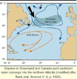
In a recent Science article authors Bard, Rostek, Turon, and Gendreau demonstrated the climatic influence of icebergs on the North Atlantic. They examined marine sediment cores from three North Atlantic holes to document the impact of Heinrich events, which sent surges of icebergs into the North Atlantic.
The study documented geochemical clues to icebergs' role in altering the ocean's salinity and chemistry. However, our concern is the spike in ice-rafted detritus (IRD) that they found during each of three Heinrich events. These occurred at approximately 16,000 years before present (ybp), 23,000 ybp, and 31,000 ybp.
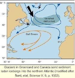
The iceberg surges carried large quantities of sediment east across the North Atlantic, which dropped as the ice melted. The IRD belt, is the site for this ice-transported sediment. If such a wide band of sediment was laid in the North Atlantic deepwater, are there IRD's deeper than those presently documented? Are they prospective oil and gas reservoirs? Where else in the deepwater and ultra-deepwater across the globe should we look for the remnants of earlier deglaciations? We know enough of the earth's glacial history to seek the answers.
East African deepwater
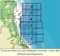
Tanzania opened its First Licensing Round for six Indian Ocean tranches between Mtwala in the south and Dar es Salaam in the north. Tranche sizes vary in area from 9,250 sq km to 13,270 sq km.
Terms are reasonable with four-year initial term, four-year first renewal, and three-year second renewal periods. No bonuses are required for licenses, but a $10,000 application fee, work program, and data purchases are mandatory for bid winners. Western Geophysical has 6,700 km of 2D data and several reports available to support companies interested in exploring the region.
The licensing round closes 19 April 2001. Contact Sirili Massay in Ddar es Salaam at Tel: 255-222-118535, Fax: 255-222-129663, or Email: [email protected].
EXPLORATION
West African search
Aker Geo is gathering a series of surveys for Vanco Energy along the West Africa coast. The Aker Amadeus, finished surveying License Area 1711 adjacent to Angola in August and is now completing a 650 sq km 3D survey offshore Namibia. The vessel will proceed to Equatorial Guinea and C
US Gulf deepwater
TGS-NOPEC is collecting a new non-exclusive 3D seismic survey over portions of the Green Canyon and Atwater Valley areas of the Gulf of Mexico. The survey is being acquired and processed in partnership with Compagnie Generale de Geophysique (CGG) using the, M/V Mistral. The survey will produce more than 1,700 sq km of new data over a 74 OCS block area.
TECHNOLOGY
Static 4C
SeaScan, Inc. has patented a permanent reservoir monitoring system for gathering time lapse seismic. The system uses a fixed array of seabed sensors using the company's Tri-Clustertrademark technology in combination with a static airgun source. The source is hung from the crane on a field's surface installation, rather than being pulled through the water over the array. See US Patent No. 6,091,668 for complete information.
Seafloor acquisition
PGS Reservoir Services announced its integrated four-component seafloor acquisition system, FOURcEtrademark. The system brings shear wave reservoir definition to deepwater fields.
It consists of a deepwater dragged array of multi-component sensors, high frequency acoustical positioning, and an integrated navigation system. Most importantly, the system can be used in water depths down to 2,000 meters.


