New seismic data shows clear prospects
Neil Hodgson
Spectrum Geo Ltd.
As Somalia announces plans to open its first offshore exploration license round in 1Q 2017, explorers analyzing new seismic data have recognized the potential of finding reserves to match those of its neighbors in East Africa. Beyond that, critically, they are discovering that Somalia’s potential is not just gas: Here lies a gem of an unexplored oil basin.
The last thing East Africa needs right now is more undeveloped gas; up to 200 tcf of gas, equivalent to more than 30 Bbbl of oil reserves, have been discovered in Mozambique and Tanzania in recent years. These discoveries are now being queued up for development and are seeking an export market. So it is with great relief that new seismic data collected in 2014-2015 offshore Somalia has revealed what has been previously missing from this prolific margin – the scent of oil.
At this year’s African Oil Week conference in Cape Town, on Nov. 1, Jamal Mursal, the Permanent Secretary to the Somalian Ministry of Petroleum and Mineral Resources, told an audience of industry senior executives that, in early 2017, the Somalian government will open an exploration licensing round for its waters. Mursal informed leaders from national and independent oil companies that after 25 years with no offshore exploration activity, the groundwork was in place to successfully open acreage to foreign investment. The exploration potential of the margin from Kenya to Puntland had been revealed by a modern seismic survey, revealing previously unseen geology, and allowing a new and exciting understanding of oil potential to be recognized.
This 2D seismic data is being interrogated by geoscientists to demonstrate the presence of the three critical factors for oil to be trapped underground. There must be a source rock – shale containing organic material that is buried at the right temperature and pressure conditions for generation. The oil that is formed must then flow through pores and fractures to a reservoir where it collects, displacing water between grains of sand, and then this oil must be trapped – where it is held underground by impermeable strata. Analysis of the new seismic data offshore Somalia has allowed the critical factors of this puzzle to be identified.
In Somalia, indeed, in any unexplored basin, an explorer’s first question is whether there is a source rock that has been buried deep enough to be mature. If the source rock is too cold (i.e. buried insufficiently) then no oil forms. If the source rock is too hot (i.e. buried too deep) then the oil is cracked or broken down to methane gas. Yet like good-tasting porridge, if the temperature is just right, the source rock will produce oil product in what is called the Goldilocks Zone.
Four source rock intervals in Somalia have been identified: an old pre-rift Karoo source of Triassic age; a syn-rift Jurassic source deposited in rifts formed by the break-up of the Gondwana super-continent; post-rift Late Cretaceous; and Early Tertiary source rocks deposited in discrete global anoxia events in the world oceans in the last 120 million years.
Industry geoscientists are using the new, multi-client 2D seismic data and nearby 25- to 40-year-old well data to clarify the architecture of the geological strata. Prior to 2015, the geology of this margin was practically unknown, as no geoscientists had ever been able to image the rocks and structures. The new seismic data, however, is revealing a wealth of structures and geology that are unique and remarkably surprising.
Broadly, the geology of the Somalian margin can be divided into a northern zone (the Obbia and Coriole basins) underlain by highly stretched continental crust (sands, shales, limestones, and old metamorphic rocks), and a southern zone (Juba-Lamu basin) underlain by oceanic crust (volcanics). In the northern area, the temperature in the earth increases rapidly with depth such that the main source rocks (Jurassic) lying a modest 2-3 km (1.2-1.8 mi) below the seabed, are mature for generating oil rather than gas today. In the south, the underlying colder oceanic crust lets the temperature rise only slowly with depth such that the main source rocks that are more deeply buried (3-4 km/1.8-2.4 mi) in this region are serendipitously still generating oil today. Oil as the primary hydrocarbon phase offshore Somalia is supported by observation on satellite data of clusters of repeating natural oil slicks on the ocean surface.
The style of traps and reservoirs visible on the new seismic data vary again between the north and the south. In the north, Jurassic and Cretaceous limestone reefs provide excellent reservoir, as do the tilted fault blocks of pre-rift Karoo sandstones. In places, the strata are deformed into huge folded structures, simple to define and evaluate, that extend over hundreds to thousands of square kilometers. Cretaceous sandstone and carbonate plays occur at several levels. In the south, a Cretaceous and Tertiary sand- and mudstone-rich delta built out over the oceanic crust, and in places and at multiple times this pile of sediments has slumped down into the basin forming what are known as mega-slides. These contain big trapping structures, similar in scale and formation to those in the Rovuma basin offshore Mozambique that have been so prolific in recent years. The data is so crisp in these areas that information about the fluid content of these structures can be deduced. Seismic reflections are known to behave idiosyncratically when they interact with oil-bearing horizons. Such characteristic tell-tale signs have been picked up within, and down-dip from the mega-slides, which is a good sign of hydrocarbon presence. Targeting these features is an industry-standard way of reducing exploration risk.
However, perhaps more unexpected and stunning are the series of folded structures that sit under the shallow-water shelf offshore Somalia. Large, possibly oil-bearing, well-defined structures with seismic indications of hydrocarbons make for low-risk exploration targets, and it is these that represent the near-term future for Somalian exploration.
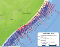
The seismic operations that acquired the data over 2014-2015 had one surprising characteristic in common – both operations, conducted over many months, were undertaken without any security incidents. On the 2015 survey, 20,582 km (12,789 mi) of 2D seismic data was acquired over a 150-day period in which 444,532 man hours were worked with no security or major HSE incidents. This was achieved by the implementation of a sound security plan that supported the operation. Although this management strategy increased the cost of the operation, it demonstrated that above-ground risks can be managed in Somalia as in most of the world’s frontier basins, with diligent planning and deliberate mitigation.
Conclusion
The announcement of the country’s upcoming license round is perfectly timed to coincide with the availability of new seismic data. This excites international geoscientists by demonstrating a clear oil-prone series of prospects offshore the whole length of the Somalian margin. In the north, large tilted fault blocks, reefal buildups, and huge anticlinal folds of rock are seen to lie next to oil generative source kitchens. In the south, huge structures similar to those seen in the super giant Rovuma basin discoveries have been observed sitting over oil-prone rather than gas-prone kitchens. Additionally, large, well-defined fold belts are found in the near-shore section offering targets that are cheap to drill with very attractive potential.
The first drilling in this exciting basin is expected to occur as early as 2018, and should open the door to this new oil province bringing much needed benefit to Somalia and a new economic stability to the region. Somalia exploration has been dormant for a generation. In those 25 years of sleep, the international exploration industry has transformed the technology available for seismic acquisition, processing, interpretation, and drilling.
Now Somalian exploration awakens to a new world with incredible new technologies and the capability to reduce exploration risk and ensure early success. It awakens not only to a stable government with capability and intent to rapidly develop Somalian natural resources, but also to the recognition that this is the part of East Africa where hydrocarbon wealth will not just be defined by the development of long-term gas projects, but from the discovery of earth’s richest natural resource prize – oil.


