Ian Voparil, Ph.D., Shell Global Solutions
Richard Crout, Ph.D., NOAA NWS National Data Buoy Center
Shell and the National Ocean and Atmospheric Administration (NOAA) are partnering to install novel technology offshore in the Gulf of Mexico to improve ocean and weather observations. The goal is to provide data to improve both the scientific understanding of the forces generated by severe weather and the accuracy of forecasts, particularly prediction of hurricane severity.
As shown by hurricanes Katrina and Rita in 2005, the United States and residents of the Gulf Coast would benefit from a better understanding of hurricanes in the GoM. At the State of the Gulf of Mexico Summit 2006, Shell Oil Co. President John Hofmeister and NOAA Administrator Vice Admiral Conrad Lautenbacher agreed to explore the use of Shell’s offshore facilities to augment NOAA’s efforts for meteorological and oceanographic (metocean) observations to better understand the forces created during hurricanes and tropical storms, and to increase the precision of storm severity forecasting.
On Feb. 13, 2008, Shell and NOAA signed a memorandum of agreement to collaborate on a number of projects using Shell offshore platforms, thereby leveraging complementary strengths, namely, NOAA’s scientific expertise with Shell’s offshore experience and infrastructure. The collaboration recognizes that while offshore facilities are clearly threatened by severe weather, as long as instruments continue to function and report data to shore, such infrastructure also could serve as sentinels watching the path of severe weather.
The projects
A general goal is to implement backup power and data transmission systems so metocean instrumentation continues to function and report as long as possible while hurricanes approach and after platforms have evacuated personnel. The potential to have access to data on wind, humidity, air and water temperature, waves, and currents in advance of a hurricane improves the capability to forecast its path and intensity. Also, the additional data will increase the density of available GoM measurements. The locations for ocean and weather observations lie along the continental shelf break at the interface between gulf-wide regional oceanic models and coastal ones, which focus on conditions important for nearshore communities along the Gulf Coast. These observations will help set proper boundary conditions for increased accuracy of coastal modeling efforts.
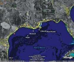
Updated weather stations: Upgrades of FAA-certified Automated Weather Observing Systems (AWOS) on Shell’s TLPs in the Gulf (Auger, Mars, Brutus, and Ram/Powell) will be supplemented with a Geostationary Operational Environmental Satellite (GOES) transmitter for direct transmission to NOAA/NDBC. A backup battery for the system will be included in the installation package. AWOS record wind speed and direction, wind gusts, temperature, dew point, altimeter setting, density altitude, visibility, variable visibility, precipitation, day/night, and cloud height and sky conditions.
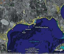
Instrument deployment locations. Green icons mark Shell’s TLPs. Yellow indicates the new weather stations, and red is the HF radar transmitter to supplement the Texas Coastal HF Radar System.
This project has the greatest potential for continued functioning as hurricanes approach. A gap in geographically important observations occurred when NDBC’s Buoy 42038 east of Flower Gardens Bank was decommissioned two years ago. NOAA sought to replace the information provided by the buoy. Shell’sAuger platform is 10 nautical miles (11.5 mi [18.5 km]) northeast of the buoy’s former location and makes a suitable replacement.
Shell also plans to place instruments on two coastal platforms on the continental shelf off of Louisiana to fill a gap in the coverage of meteorological stations. South of the Mississippi River delta, these platforms can observe storms and cold fronts that reach the shoreline and move across the region and into the south-central US. Each platform will have a simple instrument package for wind speed and direction, liquid precipitation, barometric pressure, temperature, and relative humidity.
Upper ocean heat content:At the National Hurricane Center suggestion, Shell intends to measure the temperature profile of the upper ocean from its Brutus platform. Shell plans to take water temperature measurements from the surface to ~100 m (328 ft) depth at 10 m (33 ft) intervals and to transmit that information in real-time to NOAA/NDBC. These measurements will come via a string of thermistors mounted on a coated cable at specific intervals. An induction modem would communicate information up the string to the data acquisition system on the platform topsides to be transmitted via GOES to NOAA/NDBC.
Heat of the upper ocean is significant in hurricane intensity. Generally, the temperature at the sea surface must be above 26.5° C (80º F) for hurricanes to form and intensify. Hurricanes draw energy from the upper, mixed layer of the ocean, not just from the surface, and as a hurricane moves across the ocean, thermal energy is extracted from the water below. In areas where warm waters are deeper, such as the loop current and loop eddies, the potential to intensify increases greatly for a slow moving storm.
Wave energy:When Shell installs a new wave system on the Auger platform (currently scheduled for early 2009), it will send data directly to the research community and will be a priority to receive emergency power during shut-ins and evacuation. Shell is considering a system to measure the wave field, including wave height, speed, and direction, and to calculate the direction of wave energy. Auger’s location makes such information useful for understanding the dynamics of coastal Louisiana. The MMS-funded NDBC buoys in the northern GoM also provide directional wave data. Such data is not only essential to platform and service vessel safety, and to model the Louisiana coast waves, the data also address wetlands restoration and storm surge modeling at Shell’s Coastal Environmental Modeling Laboratory at the Louisiana State University School of the Coast and Environment.
Coastal currents:High-frequency (HF) radar measures the surface currents and wave characteristics of a large area of the ocean, to a distance of 10 to 100 km (33 to 328 ft) offshore. As such, HF radar is a vital and fast-growing part of the Integrated Ocean Observing System (IOOS). The Texas General Land Office and the Shoreline Environmental Research Facility at Texas A&M University have deployed a system along the coast from Galveston to Corpus Christi, Texas. To augment this, Shell plans to install a 5 MHz bistatic transmitter on a platform in the Brazos block. This transmitter would expand the existing network to the offshore region by relaying information to the central HF radar installation onshore.
Coverage in this geographic location serves several purposes. Such information could help in oil spill response offshore, where observational, real-time data would increase the ability to predict a spill’s movement and trajectory. Coast Guard Search and Rescue missions and coastal recreation also could benefit from improved observation of coastal currents.
Atmospheric profiling:Shell also proposes a feasibility study to investigate atmosphere/ocean interactions during storms using an atmospheric microwave profiler on Brutus. While the intent is to study conditions before and during hurricanes, the profiler would provide information vital to investigating the dynamics of cold front passage at sea, the sea breeze system, and the impact of GoM moisture on severe storm and tornado formation in the central US. Temperature and humidity of the atmosphere are vital to hurricane research because they help scientists understand the stability of the atmosphere. Microwave profilers measure real-time temperature, relative humidity, and liquid content of the atmosphere from the earth’s surface to a height of ~ 10 km (33 ft) and, in doing so, help pinpoint the exact location of the troposphere, the lower part of earth’s atmosphere. NASA scientists attempt to make similar measurements by flying over, through, and around hurricanes in the Caribbean, the GoM, and the Atlantic. A profiler at Brutus would allow permanent monitoring of conditions as storms approach so atmospheric developments can be monitored over the long-term, rather than as a snapshot offered by an overflight.
Timeline
Installation of equipment is scheduled to start this summer and to be completed by late 2009. NOAA will provide storage and open access to the data via NDBC’s real-time marine information Website (www.ndbc.noaa.gov). Observations from Shell’s platforms also will be valuable to ocean observers and coastal monitoring communities. Data generated by these projects also may help address other GoM issues such as hypoxia, wetlands restoration, and storm-surge modeling. By making data available to the research and academic communities, Shell and NOAA hope that additional uses will be found.
It is critical to the US national interest that new and more robust observations be collected in the GoM. The ocean current observations collected by the oil and gas platforms in the northern Gulf are recognized by the operational weather community and scientific researchers as the most comprehensive, detailed, real-time oceanographic dataset ever collected and made available worldwide. New physical oceanographic insights constantly are being developed based on the observations. NOAA and Shell hope that plans and goals developed for their collaboration will extend those insights even further to protect marine assets and the public.
About the authors
Ian Voparil works in the Environmental Ecology and Response group of Shell Global Solutions based in Houston.
Richard Crout is responsible for overall data quality and ocean measurements at NDBC’s Data Assembly Center at the Stennis Space Center in Mississippi.
History of collaboration
This initiative builds upon a history of collaboration between Shell, other operators offshore, and the federal government. For example, a 2005 Notice to Lessees from the Minerals Management Service (MMS) requires operators of oil and gas platforms in water deeper than 400 m (1,312 ft) to deploy ocean Acoustic Doppler Current Profilers to monitor high currents related to the loop current and loop eddies in the northern Gulf of Mexico. Loop currents are fast, strong flows that can interrupt drilling and production, and endanger rigs and platforms. The real-time data go to NOAA’s National Data Buoy Center (NDBC) where they are checked by quality control and re-transmitted to the world’s forecast centers and posted on NDBC’s Website (www.ndbc.noaa.gov). The result is the most comprehensive and detailed real-time oceanographic dataset ever collected and made available worldwide.
In addition, Shell has provided meteorological data from four production platforms; two of these platforms essentially replace NDBC buoys removed due to budgetary constraints. Shell also participates in the GoM Coastal Ocean Observing System (GCOOS), providing observations and serving on organization committees. GCOOS is part of a national network of regional coastal ocean observing systems currently under development as part of the US Integrated Ocean Observing System.


