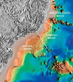
Brazil’s subsalt exploration is focused in the Santos, Campos and Espirito Santo basins. It is expected to spread to the eastern margin Jequitinhonha and Camamu-Almada basins, Petrobras Corporate Executive Manager Francisco Nepomuceno Filho, toldOffshore magazine in an exclusive interview.
All these basins, even the Campos, still are unexplored for subsalt targets. But, the subsalt section congregates all the elements considered essential for the existence of oil and gas accumulations, added Nepomuceno.
Although private sector geologists say that there may be another Campos basin subsalt, with more than 10 Bbbl of light oil reserves, Petrobras was first to affirm that Campos basin subsalt section still has billions of barrels of light oil potential to be explored, said Nepomuceno.
“Due to the urgent necessity of importing light oil to be blended at Petrobras’ old refineries with heavy crude (the bulk of Brazil’s oil output) and because of the huge tertiary/upper cretaceous oil discoveries that occurred during the ’70s, ’80s, and first half of the ’90s, Brazilian exploration remained predominantly concentrated at the Campos basin Tertiary and Upper Cretaceous reservoirs. Campos and other basins subsalt exploration was sporadic,” he explained.
“Since 2004, however, subsalt exploration has become an important exploration focus, both in the Campos basin as in the adjacent Espírito Santo and Santos basins. Based upon their interpretation Petrobras geologists and geophysicists expected to find porous-permeable reservoirs and good quality oil, as actually occurred,” added Nepomuceno.
Along the coastline from Santa Catarina state, south of Brazil to Paraíba and Pernambuco states, in northeastern region, there are sedimentary basins with a total sedimentary area of near 770,000 sq km (297,299 sq mi), with water depths up to 3,000 m (9,842 ft).
From south to north, the following gives the areas of each sedimentary basin: Santos, 350,000 sq km (13,514 sq mi); Campos, 115,000 sq km (44,402 sq mi); Espírito Santo/Mucuri, 120,000 sq km (46,332 sq mi); Cumuruxatiba, 39,000 sq km 15,058 sq mi); Jequitinhonha, 23,000 sq km (8,880 sq mi); Camamu-Almada, 23,000 sq km (8,880 sq mi); Jacuipe, 13,000 sq km (5,019 sq mi); Sergipe-Alagoas, 46,000 sq km (17,761 sq mi); and Pernambuco-Paraiba, 40,000 sq km (15,444 sq mi).
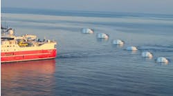
Seismic surveys have been conducted predominantly in the Campos, Santos, and Espírito Santo/Mucuri basins, and more recently in the Jequitinhonha, Camamu-Almada, and Sergipe-Alagoas basins. In the other basins, due to the fact that there were no exploration concessions available in the ANP Bid Rounds, there is less available seismic data.
Santos basin subsalt discovery
“From the first (1-RJS-617D) to the second (1-RJS-628A) well drilled in 2005 and 2006 involving deep drilling, ultra deepwater, and thick salt sections, yes, there was a significant evolution in the time of drilling and in the final well integrity, resulting in a much less expensive well, reducing the time and cost more than 200%,” said Nepomuceno.
Tests carried out by Petrobras through vertical well 1-RJS-628A drilled at 2,140 m (7,021 ft) water-depth in BM-S-11 block, a new exploratory frontier off Santos basin, confirmed last October the existence of a significant volume of 30° API light oil with the discovery of a highly productive reservoir beneath a 2,000-m (6,562-ft) thick salt base.
Petrobras is the operator of the BM-S-11 block, with 65% interest in partnership with BG (25%) and Petrogal (10%).
The 1-RJS-628A indicated a flow of 4,900 b/d of oil and 150,000 cu m/d (5.3 MMd) of natural gas (5/8 in. choke with stabilized pressure) and the gas oil ratio (GOR) around 180, said Nepomuceno.
Especially challenging, the drilling of the 1-RJS-628A well penetrated sandstone, shales, salt, and, eventually, lava flows in the subsalt. However, high pressure rather than high temperature was one main concern, said sources at Cenpes, Petrobras R&D center.
Geological information from the 1-RJS-628A well, only the second exploration well drilled in subsalt target in Santos basin, still is being evaluated. Large structures were mapped.
Although an appraisal well of this discovery is planned to be drilled early in 2007, some believe that Petrobras may have discovered a new giant field with a 90 m (295 ft) thick reservoir in a 450 sq km (174 sq mi) area.
“Now, the whole discovery area is under re-mapping and re-interpretation,” said Nepomuceno, who declined to detail the characteristics of the light oil and the natural gas Btu content produced in the well.
“Estimates concerning the future development of production (from 628) are premature. The next two wells will be drilled at 2,100 m (6,890 ft) water depth, seeking reservoir depth near 6,000 m (19,685 ft) after cutting through 2,000 m (6,562 ft) - thick salt layer,” he said.
Drilling in the adjacent BM-S-10 block also revealed good subsalt oil indications, confirmed Nepomuceno. Well 1-RJS-617D reached 7,628 m (25,026 ft) and its TVD will be 6,938 m (22,762 ft).
The region in the Santos basin is known as “cluster blocks” in the ultra deepwater (over 2,000 m [6,562 ft] water-depth) of the basin. It includes the exploration blocks BM-S-8, BM-S-9, BM-S-10, BM-S-11 (acquired during Bid Round 2 in 2000), BM-S-21, BM-S-22 and BM-S-24 (Bid Round 3 in 2001).
The “cluster blocks” total area of around 12,300 sq km (4,749 sq mi) is covered by high resolution, high quality 3D seismic. (Figure 1).
At the early cretaceous, 60 million years ago, with the cooling of the new oceanic crust, Mantiqueira mountain was formed. Later, 30 million years ago, the Serra do Mar mountain arose along with large amount of shelf. These heavy sediments moved the salt eastward and opened windows, and oil came from source rock to reservoir, principally in Campos basin. In Santos basin, most of the oil still rests below the salt. And now, two wells drilled through the salt found this oil trapped in the layers beneath the salt.
A second opinion
“It is of the utmost importance for proper economic evaluation and prospect assign risk factors to drill deeper exploration targets in this prolific realm,” said Marcio Rocha Mello, president of Brazil’s Geological Association.
He argues that “up to some time ago, Petrobras believed that the subsalt rocks were too compacted, without permeability. However, with the confirmation of the Santos basin discovery, it was proved that the salt layer acts as a cushion for the compactation as well as for temperature.”
Mello estimates that for a subsalt reserve to be commercially viable it must have a minimum of 700 MMbbl reserves. The fact that Petrobras confirmed that there were “significant quantities of reserves” in Santos opens a new window of exploratory opportunity.
“There are good chances of new discoveries off the eastern coast of Brazil including Campos, Santos, Espirito Santo basins up to Pernambuco-Paraíba basin in the north,” said Mello, who has been predicting for years that Brazil’s subsalt held billions of barrels of reserves.
The 3D petroleum system modeling study of larger areas of the greater Campos basin showed that its potential hydrocarbon reserves are much higher than predicted and suggests the deep reservoirs, ranging from Lower Cretaceous (pre-salt and Albian carbonates) to Upper Cretaceous, as the new frontier for exploration in the area, added Mello.
“Due to the complexity of the subsalt play, there are many challenges to overcome: the salt layer can be mechanically unstable, wells can lose circulation, and can encounter lava flows beneath the salt in the rift section or volcanic flows that pre-date the formation of the saltcap. Thus, drilling is very expensive. A normal well costs $35 million. Subsalt well costs will rise to between $100 million to $150 million, but it is worth it, because ‘the prize’ will be much greater,” Mello said.
In the greater Campos basin, the origin of the hydrocarbons is related to the existence of one of the best source-rock system; the Greater Lagoa Feia pre-salt, lacustrine system. Due to a unique tectonic and climatic evolution, a huge epicontinental pre-salt saline lake complex was formed during the Lower Cretaceous in the southern realm of the South Atlantic margin, comprising more than 400 m (1,312 ft) - thick organic-rich layers and extending up to the salt boundaries of the mid South Atlantic chain.
Almost 98% of the oil and gas produced in the greater Campos basin was sourced by organic-rich, pre-salt greater Lagoa Feia sediments deposited during the sag and rift phases. It is polled in Tertiary to Santonian turbidite sandstone reservoirs, ranging in depth from 2,500 to 3,500 m (8,202 to 11,483 ft), in the post-salt sequences.
Despite the abundance of these large-scale accumulations in reservoirs ranging in age from Tertiary and Upper Cretaceous, almost all the oil and gas actually comes from the much deeper pre-salt sag and rift lacustrine source rock that extends for more than 2,000 km (1,243 mi) from south Santos to north Espírito Santo basins, added Mello.
The sedimentary thickness increases from west to east with the amount of extension of the lithosphere during rifting. To the west, relatively thin Tertiary sediments directly overlie basement composed of continental crust. In the eastern part of the basin, where most of the oil and gas accumulations are, a thicker sedimentary package composed of Lower Cretaceous to Holocene units are deposited directly on attenuated basement.
The eastern part of the basin is delineated by a series of salt domes where attenuated continental crust meets through oceanic crust. Early Cretaceous crustal extension created a series of horsts and grabens. It is within these lows that the richest, lacustrine, very prolific source rocks from the Greater Lagoa Feia formation were deposited during the sag and rift stages. The different tectonic-stratigraphic evolution inside the greater Campos basin defines Campos as oil prone and Santos and Espírito Santo as oil and gas prone, Mello explained.
Campos source rocks
The most important source rocks in the South Atlantic and in the greater Campos basin are the lacustrine black shales and marls of the Neocomian to Aptian Rift and Sag sequences. They reach up to 300 m (984 ft) thickness with total organic carbon (TOC) up to 9%, composed of dominant Type I, amorphous organic matter, mainly derived from algal and bacterial remains. The depositional environment varied from brackish to saline in the Rift phase (e.g. Neocomian) with intermittent marine incursions during the Sag phase in the Aptian time.
This source rock is at the peak to post-peak stage of generation in most of the basins at depth around 5,000 m (16,404 ft). Also, 3D modeling indicates that most of the Great Lagoa Feia organic-rich sequences in the deepwater appear to have reached 80-100% transformation.
Organic-rich intervals also are found in the Late Albian-Cenomanian as a result of oceanic anoxic events. Although these rocks have high TOC’s (up to 7%) it is at an early mature stage in most of the area drilled up to now, and does not appears to be able to overcharge the post-salt reservoirs (Mello et al., 1989; HRT, 2005).
In the last five years, lacustrine heavy oil and gas accumulations have been found in the Tertiary and Upper Cretaceous reservoirs of Campos basin. From Mello’s perspective, since biodegradation is considered to be the main process of formation of heavy oil deposits in the Brazilian margin basins, and is related directly to the reservoir depth, and, therefore, to the temperature of the reservoirs, it would be logical to focus exploration in deeper targets in all the oil fields, heavy or not.
As a result, giant light oil/gas accumulations could be found just below the Upper Tertiary and Cretaceous Marlim, Albacora, Roncador, Barracuda, Jubarte, Cachalote, Golfinho, and BSS-69 oil accumulation, and any other known giant shallow horizon accumulations already present in the greater Campos basin, said Mello.
He also said oil accumulations occur throughout the whole stratigraphic column, from the Hauterivian basalts to Miocene turbidites, although 90% of the total volume found is in the widespread and continuous reservoirs of the younger Upper Tertiary sequences. Subsalt fractured basalts are the reservoir for Pampo, Badejo, and Linguado oil fields in the Badejo high.
Above the basalts, sandstones and coquinas made out of pelecipods deposited in structural highs are important reservoirs. Porosity ranges from 12% to 30% and permeability up to over 500 md. Recent data show the presence of well sorted sandstone reservoirs with very good permeability and porosity in the pre-salt sequence of Santos basin, per Nepomuceno in 2005. Carbonates and sandstones also are important reservoirs in the lower Albian Macaé formation, presenting permeability ranging from 1 to 2 darcies and porosity as high as 35% and is mostly intergranular, Mello said.
Garoupa and Enchova are typical oil fields with carbonate as reservoir. The Namorado reservoir is typical turbidite sand interbedded with marls and shales deposited during the Cenomanian/Turonian. Porosity varies from 20 to 30% and permeability is up to 1 darcy. The Namorado field is typical of this reservoir. Younger reservoirs mostly are large-scale sandstone turbidites, ranging in age from Santonian to Miocene, and represent the main accumulations, up to now, in the Marlim, Albacora, Roncador, Mexilhão, Jubarte, Cachalote, and Golfinho fields. Porosities in these fields are up to 30%, added Mello.
“Case histories teach us that where the overcharged source rocks occur at the base of the sedimentary sequence, the core of the petroleum systems shows that larger volumes of good quality hydrocarbons are preferentially associated with deeper horizons,” concluded Mello, who also is president of High Resolution Technology firm based in Rio de Janeiro.
New profile
Besides the recent subsalt light oil discovery in Santos basin, Petrobras has been changing Brazilian post-salt discovery profile from heavy crude to light oil, gas and condensates, especially due to major discoveries with commercial potential in Espirito Santo, Santos, and northeastern basins .
In Espirito Santo basin, potential light oil reserves are approximately 600 MMboe, mostly in deepwater, and Petrobras continues expanding discoveries and production.
Currently, 87 fields produce light oil according to Petrobras; twelve of them are offshore (2005 estimate).
Brazil accounts for a significant portion of current deepwater production, at around 1.4 MMb/d of oil. This should grow to nearly 2.4 MMb/d in 2009, reports IHS Energy’s Global E&P Reporting Service in Houston.
At present Brazil’s average daily production of 1.76 MMb/d of oil is some 70% heavy crude. The average daily production of gas was 43.9 MMcm (1,550 MMcfl) in September 2006.
Under the Society of Petroleum Engineers’ criteria, Brazil’s proven reserves are of 11.36 Bbbl of oil and 297 bcm (10,486 bcf) of gas.
To year-end 2005, Campos basin’s shallow water subsalt fields had produced 500 MMboe and still are producing more than 26,000 boe/d.
The Badejo, Pampo, Linguado, and Trilha fields still produce from the Campos basin subsalt section. The reservoirs are coquinas (limestones) and fractured basalts and the discovered oil is 27° to 31° API.
Nepomuceno cited examples of Petrobras production in Campos basin shallow waters subsalt through Dec. 2005:
- Badejo field already produced near 35 MMboe, is still producing around 1,300 boe/d.
- Pampo field, about 270 MMboe, is still producing around 20,000 boe/d.
- Linguado field, around 165 MMboe, is still producing around 4,500 boe/d.
- Trilha field, near 22 MMboe, is still producing some 300 boe/d.
It is difficult to estimate the cost of subsalt field development in Brazil, say experts. However, the costs could surpass those of any other Brazilian development to date. In the future, if subsalt is established as a commercial play in Brazil, several Brazilian experts envision giant field-development costs in the $2 - $4 billion range or higher.
Peter Howard Wertheim
Dayse Abrantes
Special Correspondents


