Faroe Islands hold exploration potential
Heri Ziska
Faroese Geological Survey
Hydrocarbon exploration in the Faroe Islands has had a short but hectic history, from the start of data acqui-sition in 1994 through the first licensing round, held on the back of immense optimism, and a recent drilling campaign that did not live up to this preconception, but still gave some positive results.
There are still technological challenges to exploration in the Faroe Islands, relating largely to the need for sub-basalt imaging in most of the surrounding basins. However, it is possible to map structures below more than 1 km of basalt, and these structures appear to be comparable in size to the largest offshore discoveries in Northern Europe. Physical size of a structure is, however, not enough in itself; source, reservoir, and seal of sufficient quality also need to be present. Those factors also need to be of sufficient quality at the right time for a big discovery to materialize.
Exploration history
The rights to resources in the Islands' subsoil were, after many years of negotiations with the Danish government, finally transferred to the Faroese authorities in 1992. This event marked the real beginning of hydrocarbon exploration in the Faroe Islands. Interest was driven by the knowledge of two large discoveries close to the boundary on the UK side, the BP-operated Foinaven and Schiehallion.
Another eight years would pass, however, before the first licensing round took place.
There were numerous reasons for this wait, including the need to put in place all appropriate legislation setting the terms and conditions for hydrocarbon exploration. There was also the matter of a long-disputed offshore zone between the UK and the Faroe Islands, situated between Faroese waters and the UK discoveries. At the time, this area was widely considered to be the most prospective part of the entire Faroe-Shetland Channel (the area between the Shetland and Faroe Islands). The international border in the area was finally resolved in 1999.
The period between 1992 and 2000 was not one of "wait and see" regarding hydrocarbon exploration. The first seismic survey, after the Faroese government won the right to the resources in the subsoil, was acquired in 1994, and by the time the first licensing round was opened in 2000 almost 50,000 km of 2D seismic data and 8,000 sq km of 3D seismic data had been acquired.
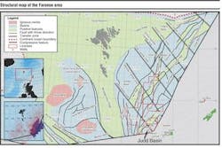
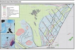
The first licensing round was a big success in terms of bid applications, and seven licenses were awarded. Four of these carried a combined total of eight commitment wells as part of the work program. In addition, all licenses had geophysical commitments. The well commitments are in the Judd basin, which covers only a small fraction of the area for exploration.
Sub-basalt challenge
There are always challenges when exploring for hydrocarbons in a frontier area. Off the Faroe Islands, there is an additional factor that has received a great deal of attention – the problems of sub basalt exploration. Most of the Faroese area is covered by flood basalts from the North Atlantic Igneous Province, and the primary prospective levels are older than the basalt. This is why sub- basalt imaging is such an issue when exploring in this region.
Seismic imaging through basalt is difficult, mainly because of the high impedance contrast at the top and base of the basalt. The result is that most of the energy is reflected and only a small part is transmitted, and it is the transmitted part that enables imaging of potential traps.
Another often cited reason for imaging difficulties is scattering of energy within the basalt. Despite these problems, it has proved possible to image structures under the flood basalts. These structures have been mapped by different people independently, and the end results have been very similar maps. This indicates that the structures are real, and not a figment of any given interpreter's imagination.
Interpretation of conventional seismic data is the most commonly used geophysical method, but it is usually supported by other methods, thus providing an integrated approach to sub-basalt exploration. The process involves integrating gravity, magnetic, marine magneto- telluric (MMT), conventional seismic, and refraction seismic data in an attempt to negate the weaknesses of one method with the corresponding strengths of other methods. This approach has helped with regard to prospect generation, and there seems to be a consensus emerging that sub-basalt exploration in the Faroe Islands is technically feasible.
Opportunities
The drilling campaign after the first licensing round only targeted the Paleocene. And the area where the wells were drilled was restricted to the Judd basin. The sought-after play was a Foinaven/Schiehallion-analogous trap farther out in the basin. Four wells have so far been drilled: one dry, one with shows, one with hydrocarbons in non-commercial quantities, and one with a 170-m gross hydrocarbon column. The status of the last is still undecided.
The mixed results from the first drilling campaign have resulted in a shift of focus with regard to exploration in the Faroe Islands from the stratigraphic play in the Judd basin to large structures below the flood basalts.
Mapping of the sub-basalt units has resulted in the discovery of several structures that appear to be comparable in size to the Clair and Troll fields in the UK and Norwegian sectors. The big uncertainty is what kind of geology is present. Is there a reservoir? Is there a seal? Is there a valid trap? These are questions that cannot be answered definitively, but the risk can be reduced by looking at the potential source/reservoir/seal scenarios in connection with the mapped structures.
Hydrocarbon exploration on the UK side of the Faroe-Shetland Channel has, during the last 30 years, targeted all stratigraphic levels from Devonian to the Eocene, and all basins have been explored. Discoveries have been made in many of the explored stratigraphic levels.
The corresponding information for the Faroe is significantly different. Only the Paleocene has been targeted for exploration, and hydrocarbons in non-economic quantities have been found in the mid-upper Paleocene, while a large hydrocarbon column has been found in the lower Paleocene. Such a result would under normal circumstances be considered a success. However, a feeling of failure still lingers relating to the very high expectations built up prior to drilling, rather than to poor results from the wells.
The remaining part of the stratigraphic section is not yet tested, and it does hold, as the other side of the channel demonstrates, significant opportunities, from discoveries such as Clair in the Devono-Carboniferous, through Strathmore in the Triassic, Solan in the Jurassic, Victory in the Cretaceous, and Tobermory in the Eocene, not to mention the Paleocene, which remains one of the primary prospective intervals in the area.
The fact that only the Judd basin has been drilled so far lends support for further exploration elsewhere in the Faroe Islands. By far the larger part of the offshore area is as yet undrilled, and it is here that the large opportunities present themselves in the shape of substantial closed structures. The size of these structures is such that they could, in a success case, contain several billion barrels of oil.
There are several unanswered questions regarding these structures. The primary one is whether there is a reservoir section of sufficient quality. This is a hard one to answer, but the Paleocene has consistently been a high quality reservoir in most wells in the Faroe-Shetland Channel. The Mesozoic section has also demonstrated reservoir of sufficient quality, and there is the possible added benefit of reservoir quality parameter preservation through early charge, overpressure, and other factors. In the case of a gas play, which is also a possibility, a poorer reservoir could yield sufficient recovery to enable production.
The hydrocarbon phase is not a foregone conclusion. The depth to the Kimmeridge Clay Formation (KCF) source rock is at present unknown, and it is therefore not possible to perform detailed maturity modeling, but the presence of a thermogenic source has been demonstrated by sea bed sampling. An upside regarding hydrocarbon generation is geochemical evidence for the presence of a Middle Jurassic source rock in addition to the KCF. A Cretaceous source rock has also been speculated, which, if present along the two mentioned source rocks, provides for many different maturity scenarios, which could potentially negate the risk of a burnt-out source rock.
Second licensing round
The large number of opportunities presented above combined with nominations from several oil companies have led to the decision to work towards a second licensing round, to be held later in 2004. The nominated areas include areas north and west of the current licenses. But no final decision has been taken yet as to exactly what areas will be included.
There are many stratigraphic levels that have proven prospective in the Faroe-Shetland Channel, and these are all possible exploration targets, with the Paleocene as the primary target. The Faroe Islands remain a high-risk area, but the potential rewards appear by far to outweigh the risks involved. ;
Reference
Carr, A. D. and Scotchman I. C. 2003. "Thermal history modelling in the southern Faroe-Shetland Basin." Petroleum Geoscience, Vol. 9. No . 4. pp 333 - 345
For more information, contact Susanna Sorensen, Faroese Ministry of Petroleum, [email protected], www.oms.fo.

